Hello,
I am trying to update SST both in d01 and d02(vortex-following). In d01, I just set sst_update=1 and use wrflowinp_d01 for WRF to automatically update SST every 6 hours, and it works.
According to this thread (Using SST update with moving inner domain), I just run the WRF for 6 hours every time, then I replaced the SST-related variables in wrfrst_d02 files. But I found in every restart file, the SST, SST_INPUT, LANDMASK, LAKEMASK would be all zero, it seems that WRF consider the vortex-following nest d02 as a place with all land but no ocean water(But since I input wrfinput_d02, it would have topography information in d02)?
This is my namelist:
interval_seconds = 21600
input_from_file = .true.,.true.,.false.
io_form_auxinput2 = 2
history_interval = 180, 180, 180
frames_per_outfile = 1, 1, 1
restart = .true.,
restart_interval = 360,
io_form_history = 2
io_form_restart = 2
io_form_input = 2
io_form_boundary = 2
debug_level = 0
auxinput4_inname = "wrflowinp_d<domain>"
auxinput4_interval = 360,
io_form_auxinput4 = 2
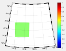
This figure shows the "landmask" in d02.

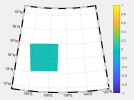
And this figure show the "SST" in d02(last 6 hours I had replaced the SST).

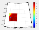
And the SST field I interpolate for this area is like this:

I replaced the SST_INPUT, SST, SSTSK, TSK, TS_URB and TSK_SAVE every 6 hours(all the same as the SST field I interpolated), but it seems that it doesn't work: in evert restart files, the SST-related fields are still zero, and the TC intensity shows no change with cold SST in d02.
I want to ask which variables should I replace in wrfrst_d02. Should I replace the LANDMASK and LAKEMASK at the same time?
I am trying to update SST both in d01 and d02(vortex-following). In d01, I just set sst_update=1 and use wrflowinp_d01 for WRF to automatically update SST every 6 hours, and it works.
According to this thread (Using SST update with moving inner domain), I just run the WRF for 6 hours every time, then I replaced the SST-related variables in wrfrst_d02 files. But I found in every restart file, the SST, SST_INPUT, LANDMASK, LAKEMASK would be all zero, it seems that WRF consider the vortex-following nest d02 as a place with all land but no ocean water(But since I input wrfinput_d02, it would have topography information in d02)?
This is my namelist:
interval_seconds = 21600
input_from_file = .true.,.true.,.false.
io_form_auxinput2 = 2
history_interval = 180, 180, 180
frames_per_outfile = 1, 1, 1
restart = .true.,
restart_interval = 360,
io_form_history = 2
io_form_restart = 2
io_form_input = 2
io_form_boundary = 2
debug_level = 0
auxinput4_inname = "wrflowinp_d<domain>"
auxinput4_interval = 360,
io_form_auxinput4 = 2
This figure shows the "landmask" in d02.

And this figure show the "SST" in d02(last 6 hours I had replaced the SST).

And the SST field I interpolate for this area is like this:

I replaced the SST_INPUT, SST, SSTSK, TSK, TS_URB and TSK_SAVE every 6 hours(all the same as the SST field I interpolated), but it seems that it doesn't work: in evert restart files, the SST-related fields are still zero, and the TC intensity shows no change with cold SST in d02.
I want to ask which variables should I replace in wrfrst_d02. Should I replace the LANDMASK and LAKEMASK at the same time?
