Dear WRF-Experts
My WRF Version is WPS-4.3.1 and WRF-4.3.3
I'm going to simulate WRF-UCM in South-Korea, So I made new landuse binary file for split LU_INDEX=1 to 31,32,33
I want to first apply landuse with my new data, and fill the nodata with usgs landuse data.
So I modify namelist.wps and GEOGRID.TBL like attached files.
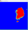
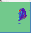
But output doesn't applied usgs_data but only new data(EGIS) , SO there is no LU on another region except south korea, and LANDMASK value -1 appeared.
I re-compiled WPS, but there is no difference.
How to solve this problem?


<landmask> : The blue area means -1 value. <LU_INDEX>
<GEOGRID.TBL>
=============================
name=LANDUSEF
priority=2
dest_type=categorical
z_dim_name=land_cat
dominant = LU_INDEX
interp_option = EGIS:nearest_neighbor
rel_path = EGIS:EGIS_UCM
name=LANDUSEF
priority=1
dest_type=categorical
z_dim_name=land_cat
dominant = LU_INDEX
landmask_water = nlcd2006_9s:17 # Calculate a landmask from this field
landmask_water = nlcd2006_30s:17 # Calculate a landmask from this field
landmask_water = nlcd2011_9s:17 # Calculate a landmask from this field
landmask_water = nlcd2006:17 # Calculate a landmask from this field
landmask_water = ssib_10m:16 # Calculate a landmask from this field
landmask_water = ssib_5m:16 # Calculate a landmask from this field
landmask_water = modis_15s:17 # Calculate a landmask from this field
landmask_water = modis_15s_lake:17,21 # Calculate a landmask from this field
landmask_water = modis_30s:17 # Calculate a landmask from this field
landmask_water = modis_30s_lake:17,21 # Calculate a landmask from this field
landmask_water = usgs_30s:16 # Calculate a landmask from this field
landmask_water = usgs_lakes:16,28 # Calculate a landmask from this field
landmask_water = modis_lakes:17,21 # Calculate a landmask from this field
landmask_water = usgs_2m:16 # Calculate a landmask from this field
landmask_water = usgs_5m:16 # Calculate a landmask from this field
landmask_water = usgs_10m:16 # Calculate a landmask from this field
landmask_water = lowres:17,21 # Calculate a landmask from this field
landmask_water = default:16 #17,21 # Calculate a landmask from this field
interp_option = nlcd2006_9s:average_gcell(0.0)
interp_option = nlcd2006_30s:average_gcell(0.0)
interp_option = nlcd2011_9s:average_gcell(0.0)
interp_option = nlcd2006:nearest_neighbor
interp_option = ssib_10m:four_pt
...
<index>
type=categorical
category_min=1
category_max=33
projection=albers_nad83
dx=90
dy=90
known_x=1
known_y=6513
known_lat=38.385313596
known_lon=125.488602204
truelat1=32.0
truelat2=40.0
stdlon=129.0
wordsize=1
tile_x=6276
tile_y=6513
tile_z=1
row_order=top_bottom
missing_value=0.
units="category"
description="33-category Urban Landuse"
My WRF Version is WPS-4.3.1 and WRF-4.3.3
I'm going to simulate WRF-UCM in South-Korea, So I made new landuse binary file for split LU_INDEX=1 to 31,32,33
I want to first apply landuse with my new data, and fill the nodata with usgs landuse data.
So I modify namelist.wps and GEOGRID.TBL like attached files.
But output doesn't applied usgs_data but only new data(EGIS) , SO there is no LU on another region except south korea, and LANDMASK value -1 appeared.
I re-compiled WPS, but there is no difference.
How to solve this problem?


<landmask> : The blue area means -1 value. <LU_INDEX>
<GEOGRID.TBL>
=============================
name=LANDUSEF
priority=2
dest_type=categorical
z_dim_name=land_cat
dominant = LU_INDEX
interp_option = EGIS:nearest_neighbor
rel_path = EGIS:EGIS_UCM
name=LANDUSEF
priority=1
dest_type=categorical
z_dim_name=land_cat
dominant = LU_INDEX
landmask_water = nlcd2006_9s:17 # Calculate a landmask from this field
landmask_water = nlcd2006_30s:17 # Calculate a landmask from this field
landmask_water = nlcd2011_9s:17 # Calculate a landmask from this field
landmask_water = nlcd2006:17 # Calculate a landmask from this field
landmask_water = ssib_10m:16 # Calculate a landmask from this field
landmask_water = ssib_5m:16 # Calculate a landmask from this field
landmask_water = modis_15s:17 # Calculate a landmask from this field
landmask_water = modis_15s_lake:17,21 # Calculate a landmask from this field
landmask_water = modis_30s:17 # Calculate a landmask from this field
landmask_water = modis_30s_lake:17,21 # Calculate a landmask from this field
landmask_water = usgs_30s:16 # Calculate a landmask from this field
landmask_water = usgs_lakes:16,28 # Calculate a landmask from this field
landmask_water = modis_lakes:17,21 # Calculate a landmask from this field
landmask_water = usgs_2m:16 # Calculate a landmask from this field
landmask_water = usgs_5m:16 # Calculate a landmask from this field
landmask_water = usgs_10m:16 # Calculate a landmask from this field
landmask_water = lowres:17,21 # Calculate a landmask from this field
landmask_water = default:16 #17,21 # Calculate a landmask from this field
interp_option = nlcd2006_9s:average_gcell(0.0)
interp_option = nlcd2006_30s:average_gcell(0.0)
interp_option = nlcd2011_9s:average_gcell(0.0)
interp_option = nlcd2006:nearest_neighbor
interp_option = ssib_10m:four_pt
...
<index>
type=categorical
category_min=1
category_max=33
projection=albers_nad83
dx=90
dy=90
known_x=1
known_y=6513
known_lat=38.385313596
known_lon=125.488602204
truelat1=32.0
truelat2=40.0
stdlon=129.0
wordsize=1
tile_x=6276
tile_y=6513
tile_z=1
row_order=top_bottom
missing_value=0.
units="category"
description="33-category Urban Landuse"

