Hi all,
I noticed some strange speckled effects in my wrfout files and managed to traces them back to the landuse in the geo_em files. Using the same GEOG inputs, I found significant differences in how the landuse is calculated between WPS v4.1 and WPS v4.4, which is having a detrimental effect on the model output.
Considering both of the attached landuse plots were generated using the same GEOG data and the same namelist (other than a slight domain size increase) options, mainly:
geog_data_res = 'default', 'default', 'default'
geog_data_path = '/path/to/geog/'
What could be going on here? Attached are:
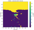
1. LU_INDEX generated using WPS v4.1
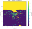
2. LU_INDEX generated using WPS v4.4
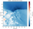
3. U10 generated using WPS/WRF v4.1 (no speckles)
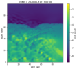
4. U10 generated using WPS/WRF v4.4 (speckles)
Where LU_INDEX artefacts are clear in the U10 field when using WPS/WRF v4.4.
I made an initial discussion post about the speckles originally here Obvious urban areas and 'speckled' fields, but feel it's more relevant here now I've narrowed down the issue.
So, any ideas? I find it odd how the same input data can be so different between versions considering the release notes don't mention any aggressive changes to how landuse is calculated.
Thanks!
Ty
I noticed some strange speckled effects in my wrfout files and managed to traces them back to the landuse in the geo_em files. Using the same GEOG inputs, I found significant differences in how the landuse is calculated between WPS v4.1 and WPS v4.4, which is having a detrimental effect on the model output.
Considering both of the attached landuse plots were generated using the same GEOG data and the same namelist (other than a slight domain size increase) options, mainly:
geog_data_res = 'default', 'default', 'default'
geog_data_path = '/path/to/geog/'
What could be going on here? Attached are:
1. LU_INDEX generated using WPS v4.1
2. LU_INDEX generated using WPS v4.4
3. U10 generated using WPS/WRF v4.1 (no speckles)
4. U10 generated using WPS/WRF v4.4 (speckles)
Where LU_INDEX artefacts are clear in the U10 field when using WPS/WRF v4.4.
I made an initial discussion post about the speckles originally here Obvious urban areas and 'speckled' fields, but feel it's more relevant here now I've narrowed down the issue.
So, any ideas? I find it odd how the same input data can be so different between versions considering the release notes don't mention any aggressive changes to how landuse is calculated.
Thanks!
Ty