Hi,
I am trying to use mcd12q1 land cover in wrf. I have implemented the data with the procedure explained in https://forum.mmm.ucar.edu/phpBB3/viewtopic.php?f=30&t=8328&p=13988&hilit=MCD12Q1#p13988
I am able to run geogrid.exe also but I am unsure about the correctness regarding the change in projection from sinusoidal to lat-long as it does not look like a true lat-long projection . Here are the things I have tried:
1) tried using gdal with the command
gdalwarp 1.tif 1_WGS84.tif -t_srs "+proj=longlat +ellps=WGS84"
This command changes the length and width from default 2400, 2400 and I get different length, width of different tiles and so I cant use that.
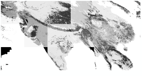
2) tried converting with Qgis but I am unsure about the projection. I have attached the output lat-long projection. I am not getting any output for LANDUSEF from geo.em. files in Panoply or Qgis.
I am a beginner in GIS.What changes should I make? Please help.
I am trying to use mcd12q1 land cover in wrf. I have implemented the data with the procedure explained in https://forum.mmm.ucar.edu/phpBB3/viewtopic.php?f=30&t=8328&p=13988&hilit=MCD12Q1#p13988
I am able to run geogrid.exe also but I am unsure about the correctness regarding the change in projection from sinusoidal to lat-long as it does not look like a true lat-long projection . Here are the things I have tried:
1) tried using gdal with the command
gdalwarp 1.tif 1_WGS84.tif -t_srs "+proj=longlat +ellps=WGS84"
This command changes the length and width from default 2400, 2400 and I get different length, width of different tiles and so I cant use that.
2) tried converting with Qgis but I am unsure about the projection. I have attached the output lat-long projection. I am not getting any output for LANDUSEF from geo.em. files in Panoply or Qgis.
I am a beginner in GIS.What changes should I make? Please help.