Hello,
We are doing a 1 km resolution 3 domain nested simulation for the Ottawa area.
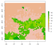
However, we found the LU_INDEX in the WRF output file came to be large pixels, which is different from that in the geo_em.d03.nc and met_em.d03.*.nc files.
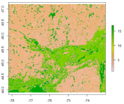
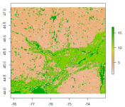
Please find the plots for LU_INDEX in geo_em, met_em and wrfout files below.
LU_INDEX in geo_em.d03.nc

LU_INDEX in met_em.d03.*.nc

It seems reasonable with fine land cover resolution in the above two figures.
So I suppose the preprocessing programs (geogrid.exe and metgrid.exe) are running well.
But after wrf.exe run, the LU_INDEX changed to large pixels:
LU_INDEX in wrfout.d03.*.nc

The static geographical data we are using is the MODIS default configuration.
As specified in the namelist.wps file:
The version of the WRF we are using is WRF V3.9.1.1.
Could anyone please let me know if it is normal that the LU_INDEX distribution changes in the WRF output file?
And how can we avoid this problem in WRF V3.9.1.1?
Thanks!
We are doing a 1 km resolution 3 domain nested simulation for the Ottawa area.
However, we found the LU_INDEX in the WRF output file came to be large pixels, which is different from that in the geo_em.d03.nc and met_em.d03.*.nc files.
Please find the plots for LU_INDEX in geo_em, met_em and wrfout files below.
LU_INDEX in geo_em.d03.nc

LU_INDEX in met_em.d03.*.nc

It seems reasonable with fine land cover resolution in the above two figures.
So I suppose the preprocessing programs (geogrid.exe and metgrid.exe) are running well.
But after wrf.exe run, the LU_INDEX changed to large pixels:
LU_INDEX in wrfout.d03.*.nc

The static geographical data we are using is the MODIS default configuration.
As specified in the namelist.wps file:
Code:
&geogrid
 parent_id         =   1,   1,    2,
 parent_grid_ratio =   1,   3,    3,
 i_parent_start    =   1,   99,   57,
 j_parent_start    =   1,  106,   73,
 e_we              = 276, 250,  391,
 e_sn              = 296, 283,  364,
 geog_data_res     = 'modis_30s+2m','modis_30s+30s','modis_30s+30s',
The version of the WRF we are using is WRF V3.9.1.1.
Could anyone please let me know if it is normal that the LU_INDEX distribution changes in the WRF output file?
And how can we avoid this problem in WRF V3.9.1.1?
Thanks!
