Dear all,
I need to change land-use of the model with Esri-30m resolution. To do this I have used "convert_geotiff".
I converted my land-use data( Esri-30m resolution) classes into MODIS classification. Esri has only 10 land use classes, while MODIS has 20 . For my study area I have only 8 category of land use. I used "convert_geotiff function" to produce binary raster files using below command:
./convert_geotiff -w 2 -c 8 -t 1200 -u "Category" -d "LAND-USE" land-use-geo.tiff
I also changed the following lines in GEOGRID.TBL.ARW :
landmask_water = Esri-30m:17,21
interp_option = Esri-30m:nearest_neighbor
rel_path = Esri-30m:Esri-landuse30m
In WPS name list changed :
geog_data_res = ' Esri-30m'
_______________________________________________________________________________
and the result is as follow:
projection = mercator
truelat1 = 0.000000
stdlon = 0.000000
known_x = 1
known_y = 33767
known_lat = 40.600704
known_lon = 46.638504
dx = 3.724413e-04
dy = 2.544101e-04
type = categorical
signed = yes
units = "Category"
description = "LAND-USE"
wordsize = 2
tile_x = 1200
tile_y = 1200
tile_z = 1
category_min = 1
category_max = 9
tile_bdr = 3
missing_value = 9.000000
scale_factor = 1.000000
row_order = bottom_top
endian = little
________________________________________________________________________________
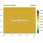
Howeve,r after doing all these steps, and running geogrid.exe, I found out that land-use file produced by geogrid.exe has only one value (attached).
I wonder why did this happen?
I noticed that projection produced by "convert_geotiff" is Mercator, but the default projection for land_use file in WPS is regular_ll'
How can I set projection as regullar_ll?
May I ask you please advice me in these regards?
Best wishes,

