Any help on the following topic would be greatly appreciated.
Running two "identical" model (differ with some defaults), one using v3.8 and one using v4.0.
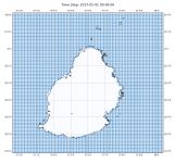
Issue I am running into is that the default land mask in v4.0 appears offset compared to the identical model from v3.8. As far as i can tell both are using using the default geog resolution of 30s however the new v4.0 uses an improved 20-class MODIS product.
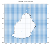
The attached scatter plot (scatterV38.png) shows the center points of each grid cell for Mauritius for v3.8. Land grid cells are white/not visible and water grid cells are blue.
Compare this to the ScatterV40.png and it seems that the new data is offset.
Thanks in advance and if there is any more helpful info. I can give let me know.
Running two "identical" model (differ with some defaults), one using v3.8 and one using v4.0.
Issue I am running into is that the default land mask in v4.0 appears offset compared to the identical model from v3.8. As far as i can tell both are using using the default geog resolution of 30s however the new v4.0 uses an improved 20-class MODIS product.
The attached scatter plot (scatterV38.png) shows the center points of each grid cell for Mauritius for v3.8. Land grid cells are white/not visible and water grid cells are blue.
Compare this to the ScatterV40.png and it seems that the new data is offset.
Thanks in advance and if there is any more helpful info. I can give let me know.