Hi everyone,
I completed a regional MPAS simulation with 15-3km resolution recently. I successfully obtained a series of "main.****.nc" files. Now I use the convert_mpas tool to convert the output files to lat-lon format (latlon.nc).
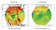
But when I used ncl to draw latlon.nc, I found that a part of the area was blank (the north side of the target area). As shown below left:
But when I use ncl to draw on the original main.****.nc file, the target area is complete. As shown below right:

I made sure my NCL scripts do not limit the lat or lon of the map.
I made sure to cover all target areas when using the convert_mpas tool. My target_domain file is:
startlat = -10.0
endlat = 90
startlon = 30.05
endlon = 180.05
nlat = 1000
nlon = 1500
Can anyone help me? I have no idea about the missing area in the latlon.nc (nc file generated by convert_mpas).
Thanks.
Best,
Monica
I completed a regional MPAS simulation with 15-3km resolution recently. I successfully obtained a series of "main.****.nc" files. Now I use the convert_mpas tool to convert the output files to lat-lon format (latlon.nc).
But when I used ncl to draw latlon.nc, I found that a part of the area was blank (the north side of the target area). As shown below left:
But when I use ncl to draw on the original main.****.nc file, the target area is complete. As shown below right:

I made sure my NCL scripts do not limit the lat or lon of the map.
I made sure to cover all target areas when using the convert_mpas tool. My target_domain file is:
startlat = -10.0
endlat = 90
startlon = 30.05
endlon = 180.05
nlat = 1000
nlon = 1500
Can anyone help me? I have no idea about the missing area in the latlon.nc (nc file generated by convert_mpas).
Thanks.
Best,
Monica
