Hello everyone,
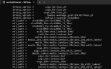
I am using WRF version 4.2.2, and the geogrid.tbl utilizes various geographical datasets required for running the real case and executing geogrid.exe. I have a question regarding the modis_landuse_20class_30s_with_lakes/ dataset—specifically, which year this dataset corresponds to in this version of WRF.
As I need to compare land use land cover classes between two different time periods, it is crucial to know the timeline of this dataset for accurate comparison.
It's urgent, so I would appreciate a prompt response.
Thanks
Aanchal Goel
IIRS, ISRO

