Hello Mduda,
I have downloaded SRTM data 3sec, and I have moved it to other coordinates on the planet, with the global mapper program.
In principle I think I have done well and I have the problem when running the geogrid.
- - - - - - - - - - - - - - - - - - - - - - - - - - - - - - - -
- - - - - - - - - - - - - - - - - - - - - - - - - - - - - - - -
1) I have downloaded the data from ->
http://dwtkns.com/srtm/
http://srtm.csi.cgiar.org/wp-content/up ... _33_07.zip
2) I modify the location of the SRTM terrain.
3) Then I run->
./convert_geotiff -w 4 -t 1200 sourceSRTM.tif
4) The application automatically created an index file ->
And my GEOGRID.TBL file ->
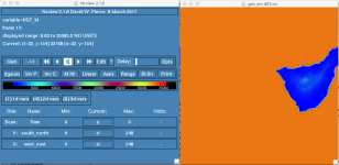
I attached the ncview output of the third domain. Look at the scale ... error file :-(
I attached the piece of SRTM file, modified by me.
Any help is welcome!!.
L Alvarez
I have downloaded SRTM data 3sec, and I have moved it to other coordinates on the planet, with the global mapper program.
In principle I think I have done well and I have the problem when running the geogrid.
- - - - - - - - - - - - - - - - - - - - - - - - - - - - - - - -
- - - - - - - - - - - - - - - - - - - - - - - - - - - - - - - -
1) I have downloaded the data from ->
http://dwtkns.com/srtm/
http://srtm.csi.cgiar.org/wp-content/up ... _33_07.zip
2) I modify the location of the SRTM terrain.
3) Then I run->
./convert_geotiff -w 4 -t 1200 sourceSRTM.tif
4) The application automatically created an index file ->
Code:
projection = regular_ll
known_x = 1
known_y = 1292
known_lat = 26.724396
known_lon = -76.679131
dx = 8.368932e-04
dy = 8.325339e-04
type = continuous
signed = yes
units = "NO UNITS"
description = "NO DESCRIPTION"
wordsize = 4
tile_x = 1200
tile_y = 1200
tile_z = 1
tile_bdr = 3
missing_value = 0.000000
scale_factor = 1.000000
row_order = bottom_top
endian = little
And my GEOGRID.TBL file ->
Code:
===============================
name = HGT_M
        priority = 1
        dest_type = continuous
        smooth_option = smth-desmth_special; smooth_passes=1
        fill_missing=0.
        interp_option = gmted2010_30s:average_gcell(4.0)+four_pt+average_4pt
        interp_option =     gtopo_30s:average_gcell(4.0)+four_pt+average_4pt
        interp_option =      gtopo_2m:four_pt
        interp_option =      gtopo_5m:four_pt
        interp_option =     gtopo_10m:four_pt
        interp_option =        lowres:average_gcell(4.0)+four_pt
        interp_option =       default:average_gcell(4.0)+four_pt+average_4pt
        interp_option = 3s:average_gcell(4.0)+four_pt+average_4pt
        rel_path = gmted2010_30s:topo_gmted2010_30s/
        rel_path =     gtopo_30s:topo_30s/
        rel_path =      gtopo_2m:topo_2m/
        rel_path =      gtopo_5m:topo_5m/
        rel_path =     gtopo_10m:topo_10m/
        rel_path =        lowres:topo_gmted2010_5m/
        rel_path =       default:topo_gmted2010_30s/
        rel_path = 3s:topo_3s/
Code:
-rw-rw-r--.  1 lalvarez lalvarez 5817744 sep 12 18:28 00001-01200.00001-01200
-rw-rw-r--.  1 lalvarez lalvarez 5817744 sep 12 18:28 00001-01200.01201-02400
-rw-rw-r--.  1 lalvarez lalvarez 5817744 sep 12 18:28 01201-02400.00001-01200
-rw-rw-r--.  1 lalvarez lalvarez 5817744 sep 12 18:28 01201-02400.01201-02400
-rw-rw-r--.  1 lalvarez lalvarez     366 sep 12 18:28 index
I attached the ncview output of the third domain. Look at the scale ... error file :-(
I attached the piece of SRTM file, modified by me.
Any help is welcome!!.
L Alvarez