Scheduled Downtime
On Friday 21 April 2023 @ 5pm MT, this website will be down for maintenance and expected to return online the morning of 24 April 2023 at the latest

Nested Domain Design Tool

JasonWok

New member
Hello developers and WPS Community,

I'm aware that we can use ncl plotgrids_new.ncl for visualization the nested domain.
However, when I want to design a very high resolution nested domain, it's pretty hard to:
  1. Satisfy all the constraints, such as 5 grids away from the parent domain.
  2. Determine if the finest domain contains the area of interest.

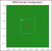
The finest domain resolution of the following configuration is 1000m-domain_04.
I'm wondering if we have some design tool to add a finer domain into the following configuration, such as 100m-domian_05.
1687397891243.png
 
Here at NCAR/MMM, we don't have a tool available, but perhaps someone in the community will have some suggestions for you!
 
Here at NCAR/MMM, we don't have a tool available, but perhaps someone in the community will have some suggestions for you!
Hello developers and WPS Community,

I'm aware that we can use ncl plotgrids_new.ncl for visualization the nested domain.
However, when I want to design a very high resolution nested domain, it's pretty hard to:
  1. Satisfy all the constraints, such as 5 grids away from the parent domain.
  2. Determine if the finest domain contains the area of interest.

The finest domain resolution of the following configuration is 1000m-domain_04.
I'm wondering if we have some design tool to add a finer domain into the following configuration, such as 100m-domian_05.

View attachment 9775
you could design a python script to load the geography image and then read in the wps file but how I'm not sure.
 
I use GIS4WRF, which is a plugin for QGIS. It will generate a namelist.wps file for you. It focuses on the design of the innermost grid and allows you to specify the padding of each nest.
 
Top