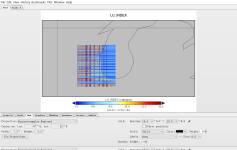
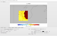
Dear all,
I tried to generate geo_em.d03 file by geogrid.
However, I noticed that when I use nlcd data (nlcd2006_9s+default), the lu_index looked very weird but the MODIS worked just fine.
I have attached my namelist.wps:
&share
wrf_core = 'ARW',
max_dom = 3,
start_date = '2009-04-01_00:00:00','2009-04-01_00:00:00','2009-04-01_00:00:00'
end_date = '2009-04-07_00:00:00','2009-04-07_00:00:00','2009-04-07_00:00:00'
interval_seconds = 3600
/
&geogrid
parent_id = 1, 1, 2,
parent_grid_ratio = 1, 3, 3,
i_parent_start = 1, 97, 95,
j_parent_start = 1, 37, 63,
e_we = 406, 280, 292,
e_sn = 313, 382, 583,
geog_data_res = 'nlcd2006_9s+30s+default','nlcd2006_9s+30s+default','nlcd2006_9s+30s+default'
dx = 4500,
dy = 4500,
map_proj = 'mercator',
ref_lat = 45.316,
ref_lon = -84.676,
truelat1 = 45.316,
truelat2 = 0.0,
stand_lon = -84.676,
geog_data_path = '/lcrc/project/WRF_Urban/WPS_GEOG/'
/
&ungrib
out_format = 'WPS',
prefix = 'SFC',
/
&metgrid
fg_name = '3D','SFC'
/
Any helps are much appreciated,
Haochen


