Hello,
I am trying to run WRF using cmip6 data as input. I have been adapting GitHub - lzhenn/cmip6-to-wrfinterm: tools to process cmip6 data to drive wrf to create the files needed to input into metgrid.
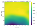
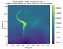
My issue is, when interpolating the cmip6 data to pressure levels, I get unrealistic values below the surface. I did not think these would matter as they should not feed into the atmospheric data. However I am running with nudging, and getting very high values for PH_NDG (even high above the surface) and MU_BDG, which are somehow creating impossibly high precipitation. Can anyone help me with this? I am not sure why the below-surface interpolation is creating these problems into the atmosphere, or if there might be a different issue.
Many thanks,
Emily


