Hi all,
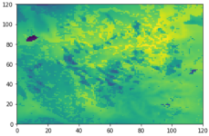
I’m noticing some unusual behaviour in my high-resolution (1 km horizontal) WRF simulations. First, lakes (or inland water bodies) are always noticeable in the surface fields (e.g., 2m temperature, 10m wind components), as shown in the attached figures (Figs. 1-3). I have tried several sensitivity tests in an attempt to smooth out the water bodies to no avail, including:
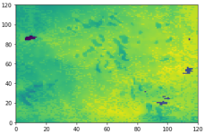
1. Using modis_landuse_20class_30s_with_lakes input geography data (Fig. 1).
2. Using modis_landuse_15class_15s_with_lakes input geography data (Fig. 2).
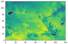
3. Using landuse_30s_with_lakes (optional) input geography data (Fig. 3).
4. Used lake_depth input data and set sf_lake_physics = 1 for all domains.
In all four tests, the lakes are clearly visible in all time steps, with lake grid cells often displaying 2m temperature values several degrees cooler/warmer in comparison to neighbouring land grid cells. Although I expect some difference in temperatures from land to water, the lack of any smoothing from lake to land grid cells seems unrealistic. All tests were performed using avg_tsfc.exe prior to running Metgrid.exe, as described in https://forum.mmm.ucar.edu/phpBB3/viewtopic.php?f=76&p=331. What could be causing this, and more importantly, how do I fix it? Furthermore, ‘speckled’ grid cells are noticeable in the surface temperature fields away from the lakes, which I assume is a land use issue (particularly in Fig. 3). Shouldn’t they be smoothed out, too?
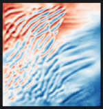
Second, there are incidents where unrealistic near-surface waves are present seemingly originating from over the lakes themselves (Fig. 4). I’m assuming this is a consequence of the violent temperature gradients from land to water causing a subtle change in wind direction which is propagated downstream. They seem rather unrealistic and (assuming the temperature over the lakes are smoothed) should not be present.
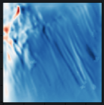
Third, there are times where unrealistic near-surface waves populate the majority of the domain (e.g., Fig. 5). They appear to arise during calm, stable, nocturnal conditions, hinting at WRF struggling to dissipate the energy within the domain and instead producing unrealistic waves. Several attempts have been made at mitigating the waves using diff_6th_opt = 2 and a variety of diff_6th_factor values, yet the problem still remains (although reducing the timestep from 6*dx to 2.5*dx and upping the diff_6th_factor to 0.5 does reduce the intensity of the waves, the patterns are still present in the near-surface fields).
An example namelist.input is also attached. All sensitivity tests were produced with the same domain configurations.
Thanks in advance for the help!
I’m noticing some unusual behaviour in my high-resolution (1 km horizontal) WRF simulations. First, lakes (or inland water bodies) are always noticeable in the surface fields (e.g., 2m temperature, 10m wind components), as shown in the attached figures (Figs. 1-3). I have tried several sensitivity tests in an attempt to smooth out the water bodies to no avail, including:
1. Using modis_landuse_20class_30s_with_lakes input geography data (Fig. 1).
2. Using modis_landuse_15class_15s_with_lakes input geography data (Fig. 2).
3. Using landuse_30s_with_lakes (optional) input geography data (Fig. 3).
4. Used lake_depth input data and set sf_lake_physics = 1 for all domains.
In all four tests, the lakes are clearly visible in all time steps, with lake grid cells often displaying 2m temperature values several degrees cooler/warmer in comparison to neighbouring land grid cells. Although I expect some difference in temperatures from land to water, the lack of any smoothing from lake to land grid cells seems unrealistic. All tests were performed using avg_tsfc.exe prior to running Metgrid.exe, as described in https://forum.mmm.ucar.edu/phpBB3/viewtopic.php?f=76&p=331. What could be causing this, and more importantly, how do I fix it? Furthermore, ‘speckled’ grid cells are noticeable in the surface temperature fields away from the lakes, which I assume is a land use issue (particularly in Fig. 3). Shouldn’t they be smoothed out, too?
Second, there are incidents where unrealistic near-surface waves are present seemingly originating from over the lakes themselves (Fig. 4). I’m assuming this is a consequence of the violent temperature gradients from land to water causing a subtle change in wind direction which is propagated downstream. They seem rather unrealistic and (assuming the temperature over the lakes are smoothed) should not be present.
Third, there are times where unrealistic near-surface waves populate the majority of the domain (e.g., Fig. 5). They appear to arise during calm, stable, nocturnal conditions, hinting at WRF struggling to dissipate the energy within the domain and instead producing unrealistic waves. Several attempts have been made at mitigating the waves using diff_6th_opt = 2 and a variety of diff_6th_factor values, yet the problem still remains (although reducing the timestep from 6*dx to 2.5*dx and upping the diff_6th_factor to 0.5 does reduce the intensity of the waves, the patterns are still present in the near-surface fields).
An example namelist.input is also attached. All sensitivity tests were produced with the same domain configurations.
Thanks in advance for the help!