odd convective precipitation over boundary from regional MPAS

JiliD

New member
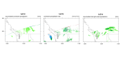
This is a 3 km MPAS limited area run over CONUS. I noticed odd convective precipitation over the boundary (see left and middle figures attached). Grid-scale precipitation is ok (the right figure). The figures are from the native meshes and no conversion is applied. The run used "convection_permitting" suite for physics which I assume uses Grell-Freitas cumulus convection. I don't know if there is anything wrong with my set up so I also attached the namelist.

thanks
 

Attachments

This is a normal phenomenon in regional MPAS output. All variables at the outermost layer of the regional MPAS are the same as the forcing data, which are not from MPAS calculation. Precipitation along the boundary is thus not physically reasonable.
We recommend to discard the results along the outermost 2 layers, i.e., where bdyMaskCell > 5.
 
Thanks for your explanation. What I don't understand is that why other fields look normal over the boundary but I only see this sharp gradient for convective precipitation. Attached are t2m, psfc, u10m and v10m. They all look smooth over boundary. Grid-scale precipitation is also not problematic in my previous post.
 

Attachments

  • mpas_boundary.png
    mpas_boundary.png
    558.7 KB · Views: 13
My understanding is that convective features in the large-scale forcing and from MPAS high-resolution simulations are quite different, which leads to the large discrepancy along the boundary.
 
Back
Top