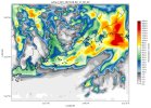
Hello, I am planning to run WRF3.9 model to simulate the rainfall. I used ERA5 grib data as the initial meteorological field input. No errors were reported at each step, but the wrfout file were strange. That is near the coast, the precipitation is distributed at some angles.
I am confused with this results. Can anyone help me please?
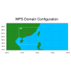
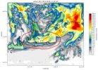
I have a rainfall case (2023-09-06_18:00:00' to '2023-09-09_00:00:00') and use three domains simulation. The red rectangle is my research area.
1. I have downloaded ERA5 data. Please see my download_era5_grib.txt. I download data from 2023-09-06 to 2023-09-09 and those data as my input era5 data:
./link_grib.csh /GPUFS/yt_ust_suhui_3/uwincm/DATA/Black_storm_era5/era5 (are my ERA5 data and namelist.wps reasonable to simulate my case)
I can successfully create met_em.d01*, met_em.d02* and met_em.d03* files.
2. Then I ln -sf met_em.d0* files to WRF/run directory and ./real.exe. I can get wrfinput_d01, wrfinput_d02, wrfinput_d03 and wrfbdy_d01. Then I run ./wrf.exe. Then wrfout files can be generated at all times. But the results look really weird. There is an angle of rainfall simulation near the coastal part. What should I do?
Thank you so much for your help in advance!


