Dear all,
I performed two tests using exactly the same ERA5 meteorological data and WPS configuration.
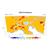
In the first test, I ran metgrid.exe without including the two invariant fields. The resulting soil moisture field (SM000007, 0–7 cm) looks relatively smooth and spatially continuous.
In the second test, I separately ungribbed the ERA5 land–sea mask and surface geopotential and included the resulting constant file in metgrid.exe using:
constants_name = 'cons:2016-01-01_00'
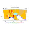
In this case, the soil moisture field changes noticeably and appears much more blocky/patchy compared with the first case.
Interestingly, in the case without the invariant fields, I checked the soil moisture values over land and found no negative values and no unrealistic values above 0.5 m³ m⁻³. However, I am not sure whether the smoother field is actually the correct interpolation or whether it only looks more reasonable visually.
Could you please advise which approach is technically correct for ERA5–WPS preprocessing? Should the ERA5 land–sea mask and surface geopotential always be supplied as invariant fields to metgrid.exe, even when the soil moisture field obtained without them appears smoother.
Thanks in advance
I performed two tests using exactly the same ERA5 meteorological data and WPS configuration.
In the first test, I ran metgrid.exe without including the two invariant fields. The resulting soil moisture field (SM000007, 0–7 cm) looks relatively smooth and spatially continuous.
In the second test, I separately ungribbed the ERA5 land–sea mask and surface geopotential and included the resulting constant file in metgrid.exe using:
constants_name = 'cons:2016-01-01_00'
In this case, the soil moisture field changes noticeably and appears much more blocky/patchy compared with the first case.
Interestingly, in the case without the invariant fields, I checked the soil moisture values over land and found no negative values and no unrealistic values above 0.5 m³ m⁻³. However, I am not sure whether the smoother field is actually the correct interpolation or whether it only looks more reasonable visually.
Could you please advise which approach is technically correct for ERA5–WPS preprocessing? Should the ERA5 land–sea mask and surface geopotential always be supplied as invariant fields to metgrid.exe, even when the soil moisture field obtained without them appears smoother.
Thanks in advance