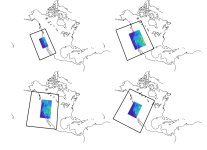
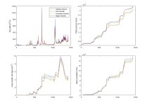
I’m working on a project to compare historical WRF simulations to end-of-century to estimate how streamflow may change. I’ve been doing test simulations to decide how we’d like to setup our model domain. We’d like to have the outer domain at 27 km and the nested one at 9 km. However, the simulations results are differing more than expected. I’ve attached two figures – one has a map of each setup (with the 27 km in the black outline and the 9 km domain shaded with elevation). The other figure is just a quick comparison of 3-hourly output for runoff, precipitation, snow water equivalent, and snowfall. I don’t have any statistics calculated, but it’s clear that there’s a bit of divergence in each variable (particularly precip and SWE) among the four domain setups.
So I’m wondering if there are any accepted best practices for setting up domains? In my experience with WRF, I’m tried to align my domains with topography, so sort of like how the top row of maps aligns with the Sierra Nevada mountain range. However, I wasn’t able to find anything in the literature that supported this.
I appreciate any suggestions and thoughts on why these simulations are giving us such different results!


