Hello,
I have been using WRF3.9.1 with ERA5 data and I have found out that some of the fields
do not seem to be interpolated well. I have noticed that with sea ice which we solved by
changing the interp_option in METGRID.TBL to
interp_option=wt_average_16pt+wt_average_4pt+search.
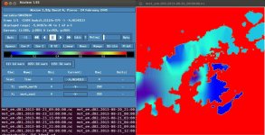
However the soil moisture also behaves awkwardly, as I have some negative values there
(see enclosed figure). I tried to change the interp_option to various combination, as described
in ARWUsersGuideV3.9, but there never were only positive values.
Obviously, this causes the Flerchinger error (http://forum.wrfforum.com/viewtopic.php?p=26565).
So I wondered if someone had a similar problem and knows how to solve it? ronbeag in the post above
suggested editing wrf_input files with ncl to set all negative values to 0.05, but I cannot quite grip ncl
so I am not sure how I would write such a script.
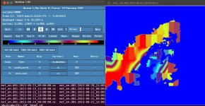
Furthermore, the snow height also has very ackward gradients (again I enclose figure). That I was also trying
to solve a little bit with interp_option in METGRID.TBL, but as it is not explained in the ARWUsersGuideV3.9 what does each interpolation
mean, it is difficult to decide which combinations might make sense.
Now I think it might also be a problem already from ungrib, so I am sorry, if I did put it into a wrong forum.
Anyway, thank you for any suggestions.
Klara
I have been using WRF3.9.1 with ERA5 data and I have found out that some of the fields
do not seem to be interpolated well. I have noticed that with sea ice which we solved by
changing the interp_option in METGRID.TBL to
interp_option=wt_average_16pt+wt_average_4pt+search.
However the soil moisture also behaves awkwardly, as I have some negative values there
(see enclosed figure). I tried to change the interp_option to various combination, as described
in ARWUsersGuideV3.9, but there never were only positive values.
Obviously, this causes the Flerchinger error (http://forum.wrfforum.com/viewtopic.php?p=26565).
So I wondered if someone had a similar problem and knows how to solve it? ronbeag in the post above
suggested editing wrf_input files with ncl to set all negative values to 0.05, but I cannot quite grip ncl
so I am not sure how I would write such a script.
Furthermore, the snow height also has very ackward gradients (again I enclose figure). That I was also trying
to solve a little bit with interp_option in METGRID.TBL, but as it is not explained in the ARWUsersGuideV3.9 what does each interpolation
mean, it is difficult to decide which combinations might make sense.
Now I think it might also be a problem already from ungrib, so I am sorry, if I did put it into a wrong forum.
Anyway, thank you for any suggestions.
Klara