MartinHagman
Member
Hi all!
The met_em files still have 138 levels because they are not vertically interpolated yet. If I take the GHT variable for one grid point, in one met_em file, this is the vertical levels above sea level in meters. After that I subtract the SOILHEIGHT(terrain field from source analysis) for that point in the grid, because then I am left with 138 levels which are the height above ground for that point. Am I right?
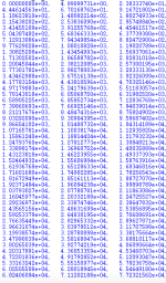
In the attached file I have printed these heights and I see that the two lowest levels is 0 m and 5 m. The lowest vertical level in ECMWF data is 10 meters, so I wonder why the lowest level in the met_em files are 5 meters in this case and not 10 m?
The reason why I wonder is that I want to plot some parameter in the met_em files against height to compare with the same parameter from a GRIB-file, just to see what the horisontal interpolation does to the data.
So, why do the heights look like they do in the attached file? I mean, nothing is done vertically yet, so should not the vertical levels be the same as in the ECMWF data? Does it have something to do with that the SOILHEIGHT in the actual point is inexact or is it something else that happens during the horisontal interpolation? Am I doing the right thing, or is it something that I have missed?
When I want to plot vertical soundings with variables in the met_em files to compare with vertical soundings from the GRIB files, do I use the vertical levels in the met_em file or do I use the vertical levels in the GRIB file? What is right here, or is both OK?
Thanks!
//Martin

