Scheduled Downtime
On Friday 21 April 2023 @ 5pm MT, this website will be down for maintenance and expected to return online the morning of 24 April 2023 at the latest

(RESOLVED) Missing skin temperature near the tropics in the met_em files

This post was from a previous version of the WRF&MPAS-A Support Forum. New replies have been disabled and if you have follow up questions related to this post, then please start a new thread from the forum home page.

zeyuxue

New member
Hi all,

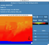
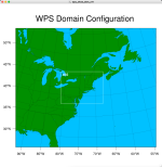
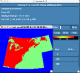
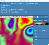
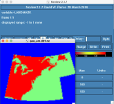
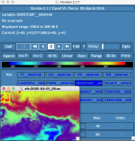
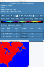
I successfully conducted some two-domain-nested WRF simulations over the NEUS driven by ERA5 reanalysis data and WRF V3 USGS Static Data; however, when I double the size of the outer domain to include a part of the tropics as shown below, there is a fatal error when I run real.exe: "FATAL CALLED FROM FILE: <stdin> LINE: 2619 grid%tsk unreasonable.". I checked the met_em files and find the skin temperature is missing near the tropics as shown below; however, other variables like PMSL look good. Then I find the LANDMASK in met_em files only covers the US and that might be the problem.

Could someone please tell me why the skin temperature is missing near the tropics?

Thank you so much for your kind help!

Best,
Zeyu
 

Attachments

  • skin_temp.png
    skin_temp.png
    83.1 KB · Views: 894
  • domain.png
    domain.png
    216 KB · Views: 893
  • LANDMASK.png
    LANDMASK.png
    98.6 KB · Views: 892
  • pmsl.png
    pmsl.png
    181.8 KB · Views: 892
Hi Zeyu,
Can you try to check the raw ERA5 data files to see if you are missing skin temperature in those, as well? You can use a plotting method for the intermediate files (see this presentation, - starting at slide 17).

I'm not sure how you obtained the input data files, but if you downloaded each variable, one at a time, and if you were grabbing a subset of data, it could be possible that you somehow missed the southern portion of your domain.
 
Hi Kelly,

Thank you so much for your suggestions. I tried to enlarge the subset of ERA5 used to drive WPS; however, the same problem still exists and other variables like RH look all good instead of the skin temperature. Also, following your instruction, I examined the intermediate files from ungrid.exe and we can see that the skin temperature from it looks good. It seems the problem comes from the geogrid.exe and the USGS geographic data I used because we can see from the geo_em files the LANDMASK does not include regions near the tropics which might make WPS unable to interpolate or adjust the skin temperature in metgrid.exe.

Bests,
Zeyu
 

Attachments

  • land_mask.png
    land_mask.png
    98.1 KB · Views: 855
  • skin_temp_intermediate.png
    skin_temp_intermediate.png
    163.8 KB · Views: 855
Zeyu,
Thanks for sending those and for the explanation. When you processed the ERA5 data, did you include the invariant data? If not, take a look at this FAQ to make sure you're doing that correctly. Otherwise, please attach your namelist.wps file so that I can see the settings you have in there. Thanks!
 
Hi Kelly,

I tried to place the ERA5_INVARIANT file under the WPS directory and add that command line into namelist as you suggested; however, the same problem still exists. Also, I have conducted several simulations over a smaller domain without this ERA5_INVARIANT file and they can produce reasonable simulations so I do not think the problem comes from it. The USGS geographic data I used was downloaded from this site (https://www2.mmm.ucar.edu/wrf/users/download/get_sources_wps_geog_V3.html) and attached are the namelist I used, the intermediate surface data, and the met_em file.

Thank you so much for your kind help!

Bests,
Zeyu
 

Attachments

  • namelist.wps
    1.5 KB · Views: 37
  • sfc_2005-04-01_00.nc
    210.2 KB · Views: 37
  • met_em.d01.2005-04-01_00_00_00.nc
    22.9 MB · Views: 42
Hi Zeyu,
I just ran a test with your namelist.wps file and my geo_em.d01.nc file shows a LANDMASK that looks correct (attaching so you can see). I did run with a newer version of WPS, though. Have you tried to re-run geogrid since the beginning of this? I just wonder if something went wrong there. If that doesn't make any difference, let me know which version of WPS you're using and I can test that. Did you make any changes to the GEOGRID.TBL or any other files that could have potentially caused the issue?
 

Attachments

  • wrfhelp_geo_em_LANDMASK.png
    wrfhelp_geo_em_LANDMASK.png
    52.5 KB · Views: 805
Hi Kelly,

Thank you so much for your help! I did not change any files under the WPS directory and used the Vtable.ERA-interim.pl. I re-downloaded and re-ran the WPS; however, the same problems still exist. The WPS I used was WPS 3.9.1.1. I also attached the geo_em files and python script used to download ERA5 data. Please have a check.

Thanks again for your kind help!

Bests,
Zeyu
 

Attachments

  • geo_em.d01.nc
    13.6 MB · Views: 31
  • geo_em.d02.nc
    9.9 MB · Views: 33
  • download_200504.py
    2.7 KB · Views: 35
Zeyu,
I think we can likely determine the issue is happening prior to your processing of ERA data since your geo_em.d01 file is showing missing data. I tried your namelist again with WPSV3.9 (which is the version your geo_em* files say) and I'm still getting the same plot as I attached in my previous message. Can you go into your directory /global/cscratch1/sd/zx2217/geog/geog/ and issue the following:
Code:
ls -ls >& geog.txt
and send me that geog.txt file? I'd like to see exactly what static data you have in there. Thanks!
 
Hi Kelly,

Right, that is also my guess. Attached is the list of files and I downloaded the them from the first and third columns in this website (https://www2.mmm.ucar.edu/wrf/users/download/get_sources_wps_geog_V3.html).

Thank you so much for your help!

Bests,
Zeyu
 

Attachments

  • geog.txt
    3.8 KB · Views: 37
Hi Kelly,

Hope you had a good Christmas. Have you figured out what's the problem of the geographic data?

Thank you very much for your kind help!

Bests,
Zeyu
 
Hi Zeyu,
Thank you, and I apologize for the delay. I took a couple of weeks off for the holidays.

I ran another test. This time I ran geogrid using your namelist.wps, and I downloaded the exact geog data you mentioned (columns 1 and 3 from here) and made sure to point to that data. I am still getting the correct LANDMASK plot (as shown in the image I attached above).

However, I compared the size of our geog static data files and one thing that stands out to me is the size of your "landuse_30x_with_lakes" directory, compared to mine. This is the landuse that is used when you set geog_data_res = 'usgs_lakes.' The size of your directory is 57344 and mine is 65536. I wonder if yours is missing something. Can you try to download just that single static file again and see what size it is when unpacked? If it is the size of mine, replace the older directory with the new one and try running geogrid again.

If you're still seeing the same problem, can you try to recompile WPS and then run again? This shouldn't be the issue, but we have certainly seen odder things in the past. If that still doesn't help, please also send your WPS/geogrid/GEOGRID.TBL file so that I can compare to mine. Thanks!

For additional verification, I'm attaching the namelist I'm using for you - just to make sure it's the exact same one.
 

Attachments

  • namelist.wps
    811 bytes · Views: 29
Hi Kelly,

No problem, I fully understand.

Yesterday I re-compiled the WPS and re-downloaded the geog data, and then I found the LANDMASK and SKINTEMP are correct in the met_em files I got. Probably some files are purged since the Cori I used usually purged inactive files. I think now my WPS can work.

Thank you so much for all your patience and kind help! Have a great week!

Bests,
Zeyu
 
Top