Scheduled Downtime
On Friday 21 April 2023 @ 5pm MT, this website will be down for maintenance and expected to return online the morning of 24 April 2023 at the latest

(RESOLVED) plotgrids_new.ncl Draw Wrong Picture in Polar Regions

This post was from a previous version of the WRF&MPAS-A Support Forum. New replies have been disabled and if you have follow up questions related to this post, then please start a new thread from the forum home page.

Yang_7Ke

New member
Hi

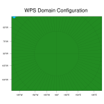
I want draw a picture of Polar Stereographic range from 70°S to 90°S.
Hence, "ncl plotgrids_new.ncl" was executed in terminal.
The value of truelat1 should be set to -200, not -70. Then can I see a picture of Polar Stereographic range from 70°S to 90°S.
But, provided that I want to run geogrid.exe, the correct value is -70.

I wonder if there is a bug with respect to drawing a picture of Polar Stereographic.
 
Hi,
Can you attach the namelist.wps file you are using (to run the WPS executables), and let me know which version of WPS you are using?
Thanks!
 
The version of WPS is 4.0
And namelist、plotgrids_new.ncl and resulting patterns are all attached here.
 

Attachments

  • namelist.wps
    1.3 KB · Views: 54
  • plotgrids_new.txt
    7.4 KB · Views: 53
  • wps_show_dom.png
    wps_show_dom.png
    121.8 KB · Views: 970
Thanks for sending those. I'm seeing the same thing you are. I'll take a look and see if I can figure out what's going on, and get back to you.
 
The plot looks correct to me. With 74 x 61 grid points and a nominal grid distance of 30 km, we should expect the domain to cover about 2190 km x 1800 km ignoring map scale distortion, which is what I think the plot is showing (assuming the latitude grid is drawn every 5 degrees). If you need your model domain to cover a larger geographic area, you should increase either e_we and e_sn or dx and dy in your namelist.wps file. You might also want to take a look at these slides to understand the role of the true latitude(s) of various map projections.
 
Thank you so much
I've got your idea.
The way to to cover a larger geographic area is increasing e_we , dx..., instead of changing truelat1.
Though I can get the pattern I want by changing truelat1, it won't work for executing geogrid.exe.
 
Top