Zhengzefeng
New member
Hello, WRF team
The default LAI data is too old to use in my interest region, thus I use another LAI dataset to substitute the default one.
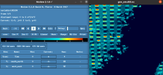
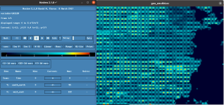
I created a new folder to store the new dataset and wrote the index file, and I changed the path of LAI12m in GEOGRID.TBL correctly, but when I check the LAI12M of the output files, the distribution of the data is abnormal. By the way, the resolution of the d03 is 3km and d04 is 1km and the resolution of the new data is 1km, too.


The LAI12M part in the GEOGRID.TBL is as below, and the index file is attached.
===============================
name=LAI12M
priority=1
dest_type=continuous
interp_option=modis_lai:average_gcell(4.0)+four_pt+average_4pt+average_16pt+search
interp_option= lowres:average_gcell(4.0)+four_pt+wt_average_4pt+wt_average_16pt+search
interp_option=default:average_gcell(4.0)+four_pt+average_4pt+average_16pt+search
z_dim_name=month
masked = water
fill_missing = 0.
rel_path=modis_lai:lai_modis_30s/
rel_path= lowres:lai_modis_10m/
rel_path=default:lai_2017_193/
flag_in_output=FLAG_LAI12M
===============================
I'm curious about what caused the problem and how to solve it, maybe the interpolation method?
Thanks,
Zefeng Zheng
The default LAI data is too old to use in my interest region, thus I use another LAI dataset to substitute the default one.
I created a new folder to store the new dataset and wrote the index file, and I changed the path of LAI12m in GEOGRID.TBL correctly, but when I check the LAI12M of the output files, the distribution of the data is abnormal. By the way, the resolution of the d03 is 3km and d04 is 1km and the resolution of the new data is 1km, too.


The LAI12M part in the GEOGRID.TBL is as below, and the index file is attached.
===============================
name=LAI12M
priority=1
dest_type=continuous
interp_option=modis_lai:average_gcell(4.0)+four_pt+average_4pt+average_16pt+search
interp_option= lowres:average_gcell(4.0)+four_pt+wt_average_4pt+wt_average_16pt+search
interp_option=default:average_gcell(4.0)+four_pt+average_4pt+average_16pt+search
z_dim_name=month
masked = water
fill_missing = 0.
rel_path=modis_lai:lai_modis_30s/
rel_path= lowres:lai_modis_10m/
rel_path=default:lai_2017_193/
flag_in_output=FLAG_LAI12M
===============================
I'm curious about what caused the problem and how to solve it, maybe the interpolation method?
Thanks,
Zefeng Zheng
