Scheduled Downtime
On Friday 21 April 2023 @ 5pm MT, this website will be down for maintenance and expected to return online the morning of 24 April 2023 at the latest

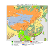
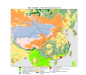
(RESOLVED) There are some differences between WRF3.9.1 MODIS 15s and 30s land cover in China?

This post was from a previous version of the WRF&MPAS-A Support Forum. New replies have been disabled and if you have follow up questions related to this post, then please start a new thread from the forum home page.

gc13141112

New member
We found some differences between WRF3.9.1 MODIS 15s and 30s land cover in China. Can someone explain these? Thanks for your help in advance! We plot these figures of MODIS 15s and 30s land cover as follows:
 

Attachments

  • wrf_modis_15s.png
    wrf_modis_15s.png
    528.3 KB · Views: 974
  • wrf_modis_30s.png
    wrf_modis_30s.png
    530.5 KB · Views: 974
We do realize some difference between MODIS 30s and MODIS 15s. Before we come up with a solution, would you please stay with the MODIS 15s data? This is because our preliminary examination shows that the 15s data is more realistic.
 
Ming Chen said:
We do realize some difference between MODIS 30s and MODIS 15s. Before we come up with a solution, would you please stay with the MODIS 15s data? This is because our preliminary examination shows that the 15s data is more realistic.

Thanks for your reply.
Our domain resolution is 27km and clearly urban categories using the 15s MODIS data do not represent urban areas in China realistically. The 30s data look a little bit better considering urban areas. Please advice!
 
I don't think 27-km is a good option for describing urban lands type. I am actually perplexed why the 30s modis data yields better results than 15s data. Our test shows that the 15s data can better show the geographic distribution of lands type.
 
Top