I have a "Segmentation fault" problem when running a WRF model; how can I solve this problem? This problem has been bothering me for days.
1. First of all, I have enough disk memory.
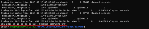
wwp@DESKTOP-7SCCTR2:/mnt/e/Coupled_WRF_WRF-Hydro/run/WRF$ cat rsl.error.0000
taskid: 0 hostname: DESKTOP-7SCCTR2
starting wrf task 0 of 1
module_io_quilt_old.F 2931 F
Quilting with 1 groups of 0 I/O tasks.
Ntasks in X 1 , ntasks in Y 1
*************************************
Configuring physics suite 'conus'
mp_physics: 3* 3*
cu_physics: 0* 0*
ra_lw_physics: 1* 1*
ra_sw_physics: 1* 1*
bl_pbl_physics: 1* 1*
sf_sfclay_physics: 1* 1*
sf_surface_physics: 4* 4*
(* = option overrides suite setting)
*************************************
Domain # 1: dx = 3000.000 m
Domain # 2: dx = 1000.000 m
WRF V4.2.1 MODEL
*************************************
Parent domain
ids,ide,jds,jde 1 42 1 42
ims,ime,jms,jme -4 47 -4 47
ips,ipe,jps,jpe 1 42 1 42
*************************************
DYNAMICS OPTION: Eulerian Mass Coordinate
alloc_space_field: domain 1 , 49016620 bytes allocated
med_initialdata_input: calling input_input
Input data is acceptable to use: wrfinput_d01
CURRENT DATE = 2013-09-09_18:00:00
SIMULATION START DATE = 2013-09-09_18:00:00
Timing for processing wrfinput file (stream 0) for domain 1: 0.54256 elapsed seconds
Max map factor in domain 1 = 1.00. Scale the dt in the model accordingly.
D01: Time step = 15.0000000 (s)
D01: Grid Distance = 3.00000000 (km)
D01: Grid Distance Ratio dt/dx = 5.00000000 (s/km)
D01: Ratio Including Maximum Map Factor = 4.99949980 (s/km)
D01: NML defined reasonable_time_step_ratio = 6.00000000
INPUT LandUse = "MODIFIED_IGBP_MODIS_NOAH"
LANDUSE TYPE = "MODIFIED_IGBP_MODIS_NOAH" FOUND 33 CATEGORIES 2 SEASONS WATER CATEGORY = 17 SNOW CATEGORY = 15
SOIL TEXTURE CLASSIFICATION = STAS FOUND 19 CATEGORIES
*************************************
Nesting domain
ids,ide,jds,jde 1 52 1 31
ims,ime,jms,jme -4 57 -4 36
ips,ipe,jps,jpe 1 52 1 31
INTERMEDIATE domain
ids,ide,jds,jde 11 33 15 30
ims,ime,jms,jme 6 38 10 35
ips,ipe,jps,jpe 9 35 13 32
*************************************
d01 2013-09-09_18:00:00 alloc_space_field: domain 2 , 4870008 bytes allocated
d01 2013-09-09_18:00:00 alloc_space_field: domain 2 , 46270180 bytes allocated
d01 2013-09-09_18:00:00 *** Initializing nest domain # 2 from an input file. ***
d01 2013-09-09_18:00:00 med_initialdata_input: calling input_input
d01 2013-09-09_18:00:00 Input data is acceptable to use: wrfinput_d02
Timing for processing wrfinput file (stream 0) for domain 2: 0.59451 elapsed seconds
INPUT LandUse = "MODIFIED_IGBP_MODIS_NOAH"
LANDUSE TYPE = "MODIFIED_IGBP_MODIS_NOAH" FOUND 33 CATEGORIES 2 SEASONS WATER CATEGORY = 17 SNOW CATEGORY = 15
SOIL TEXTURE CLASSIFICATION = STAS FOUND 19 CATEGORIES
INPUT LandUse = "MODIFIED_IGBP_MODIS_NOAH"
LANDUSE TYPE = "MODIFIED_IGBP_MODIS_NOAH" FOUND 33 CATEGORIES 2 SEASONS WATER CATEGORY = 17 SNOW CATEGORY = 15
SOIL TEXTURE CLASSIFICATION = STAS FOUND 19 CATEGORIES
Max map factor in domain 1 = 1.00. Scale the dt in the model accordingly.
D01: Time step = 15.0000000 (s)
D01: Grid Distance = 3.00000000 (km)
D01: Grid Distance Ratio dt/dx = 5.00000000 (s/km)
D01: Ratio Including Maximum Map Factor = 4.99949980 (s/km)
D01: NML defined reasonable_time_step_ratio = 6.00000000
INPUT LandUse = "MODIFIED_IGBP_MODIS_NOAH"
LANDUSE TYPE = "MODIFIED_IGBP_MODIS_NOAH" FOUND 33 CATEGORIES 2 SEASONS WATER CATEGORY = 17 SNOW CATEGORY = 15
Program received signal SIGSEGV: Segmentation fault - invalid memory reference.
Backtrace for this error:
#0 0x7fe183d97d11 in ???
#1 0x7fe183d96ee5 in ???
#2 0x7fe183a3008f in ???
at /build/glibc-BHL3KM/glibc-2.31/signal/../sysdeps/unix/sysv/linux/x86_64/sigaction.c:0
#3 0x55c32795e066 in ???
#4 0x55c32794fe68 in ???
#5 0x55c3266f33cd in ???
#6 0x55c3261f942f in ???
#7 0x55c3260a1c5d in ???
#8 0x55c325273cc0 in ???
#9 0x55c32527432d in ???
#10 0x55c325205467 in ???
#11 0x55c325204e9e in ???
#12 0x7fe183a11082 in __libc_start_main
at ../csu/libc-start.c:308
#13 0x55c325204edd in ???
#14 0xffffffffffffffff in ???
Please help me to see how I can solve this problem.
1. First of all, I have enough disk memory.
wwp@DESKTOP-7SCCTR2:/mnt/e/Coupled_WRF_WRF-Hydro/run/WRF$ cat rsl.error.0000
taskid: 0 hostname: DESKTOP-7SCCTR2
starting wrf task 0 of 1
module_io_quilt_old.F 2931 F
Quilting with 1 groups of 0 I/O tasks.
Ntasks in X 1 , ntasks in Y 1
*************************************
Configuring physics suite 'conus'
mp_physics: 3* 3*
cu_physics: 0* 0*
ra_lw_physics: 1* 1*
ra_sw_physics: 1* 1*
bl_pbl_physics: 1* 1*
sf_sfclay_physics: 1* 1*
sf_surface_physics: 4* 4*
(* = option overrides suite setting)
*************************************
Domain # 1: dx = 3000.000 m
Domain # 2: dx = 1000.000 m
WRF V4.2.1 MODEL
*************************************
Parent domain
ids,ide,jds,jde 1 42 1 42
ims,ime,jms,jme -4 47 -4 47
ips,ipe,jps,jpe 1 42 1 42
*************************************
DYNAMICS OPTION: Eulerian Mass Coordinate
alloc_space_field: domain 1 , 49016620 bytes allocated
med_initialdata_input: calling input_input
Input data is acceptable to use: wrfinput_d01
CURRENT DATE = 2013-09-09_18:00:00
SIMULATION START DATE = 2013-09-09_18:00:00
Timing for processing wrfinput file (stream 0) for domain 1: 0.54256 elapsed seconds
Max map factor in domain 1 = 1.00. Scale the dt in the model accordingly.
D01: Time step = 15.0000000 (s)
D01: Grid Distance = 3.00000000 (km)
D01: Grid Distance Ratio dt/dx = 5.00000000 (s/km)
D01: Ratio Including Maximum Map Factor = 4.99949980 (s/km)
D01: NML defined reasonable_time_step_ratio = 6.00000000
INPUT LandUse = "MODIFIED_IGBP_MODIS_NOAH"
LANDUSE TYPE = "MODIFIED_IGBP_MODIS_NOAH" FOUND 33 CATEGORIES 2 SEASONS WATER CATEGORY = 17 SNOW CATEGORY = 15
SOIL TEXTURE CLASSIFICATION = STAS FOUND 19 CATEGORIES
*************************************
Nesting domain
ids,ide,jds,jde 1 52 1 31
ims,ime,jms,jme -4 57 -4 36
ips,ipe,jps,jpe 1 52 1 31
INTERMEDIATE domain
ids,ide,jds,jde 11 33 15 30
ims,ime,jms,jme 6 38 10 35
ips,ipe,jps,jpe 9 35 13 32
*************************************
d01 2013-09-09_18:00:00 alloc_space_field: domain 2 , 4870008 bytes allocated
d01 2013-09-09_18:00:00 alloc_space_field: domain 2 , 46270180 bytes allocated
d01 2013-09-09_18:00:00 *** Initializing nest domain # 2 from an input file. ***
d01 2013-09-09_18:00:00 med_initialdata_input: calling input_input
d01 2013-09-09_18:00:00 Input data is acceptable to use: wrfinput_d02
Timing for processing wrfinput file (stream 0) for domain 2: 0.59451 elapsed seconds
INPUT LandUse = "MODIFIED_IGBP_MODIS_NOAH"
LANDUSE TYPE = "MODIFIED_IGBP_MODIS_NOAH" FOUND 33 CATEGORIES 2 SEASONS WATER CATEGORY = 17 SNOW CATEGORY = 15
SOIL TEXTURE CLASSIFICATION = STAS FOUND 19 CATEGORIES
INPUT LandUse = "MODIFIED_IGBP_MODIS_NOAH"
LANDUSE TYPE = "MODIFIED_IGBP_MODIS_NOAH" FOUND 33 CATEGORIES 2 SEASONS WATER CATEGORY = 17 SNOW CATEGORY = 15
SOIL TEXTURE CLASSIFICATION = STAS FOUND 19 CATEGORIES
Max map factor in domain 1 = 1.00. Scale the dt in the model accordingly.
D01: Time step = 15.0000000 (s)
D01: Grid Distance = 3.00000000 (km)
D01: Grid Distance Ratio dt/dx = 5.00000000 (s/km)
D01: Ratio Including Maximum Map Factor = 4.99949980 (s/km)
D01: NML defined reasonable_time_step_ratio = 6.00000000
INPUT LandUse = "MODIFIED_IGBP_MODIS_NOAH"
LANDUSE TYPE = "MODIFIED_IGBP_MODIS_NOAH" FOUND 33 CATEGORIES 2 SEASONS WATER CATEGORY = 17 SNOW CATEGORY = 15
Program received signal SIGSEGV: Segmentation fault - invalid memory reference.
Backtrace for this error:
#0 0x7fe183d97d11 in ???
#1 0x7fe183d96ee5 in ???
#2 0x7fe183a3008f in ???
at /build/glibc-BHL3KM/glibc-2.31/signal/../sysdeps/unix/sysv/linux/x86_64/sigaction.c:0
#3 0x55c32795e066 in ???
#4 0x55c32794fe68 in ???
#5 0x55c3266f33cd in ???
#6 0x55c3261f942f in ???
#7 0x55c3260a1c5d in ???
#8 0x55c325273cc0 in ???
#9 0x55c32527432d in ???
#10 0x55c325205467 in ???
#11 0x55c325204e9e in ???
#12 0x7fe183a11082 in __libc_start_main
at ../csu/libc-start.c:308
#13 0x55c325204edd in ???
#14 0xffffffffffffffff in ???
Please help me to see how I can solve this problem.