phillipyeh
New member
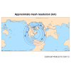
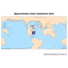
I started with the 92-25 km circular mesh, centered the higher resolution portion over the Northeast US (40N, 73W), cut out a circular region with radius 17000 km, and then used the scale_region.py tool to scale it down by a factor of 8.
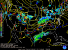
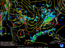
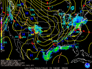
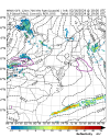
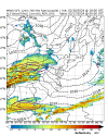
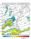
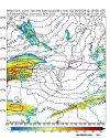
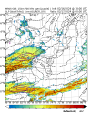
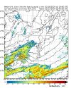
I then ran a 24-hour simulation starting 18UTC on 16 Feb 2024. I was able to successfully generate output files, with no error messages in the log files. However, when I look at the output, it does not match the observed output at all. In particular, over the Eastern US, the precipitation is in the wrong location, and the pressure/height fields do not match observations.
I checked the land-ocean mask in the history* files, and the mask is in the correct place. So the issue does not appear to be with the grid.nc or static.nc files.
The grid files and output are located in this cloud directory:
 stonybrookmedicine.box.com
Let me know if you need anything else. Thanks!
I then ran a 24-hour simulation starting 18UTC on 16 Feb 2024. I was able to successfully generate output files, with no error messages in the log files. However, when I look at the output, it does not match the observed output at all. In particular, over the Eastern US, the precipitation is in the wrong location, and the pressure/height fields do not match observations.
I checked the land-ocean mask in the history* files, and the mask is in the correct place. So the issue does not appear to be with the grid.nc or static.nc files.
The grid files and output are located in this cloud directory:
Box
stonybrookmedicine.box.com
Let me know if you need anything else. Thanks!