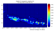
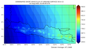
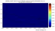
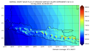
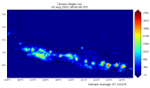
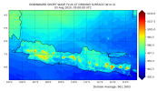
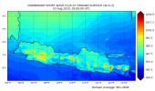
I am running a 3 domain (9- ,3- ,1-km) WRF simulation for the month of August 2020, centered over the island of Java in Indonesia. The mountains over island are higher than 2.5 km. However, there is not difference in the shortwave downward shortwave radiation (SWDOWN) when I turn on the slope_rad and topo_shading flags. I have attached the elevation map, as well as 2 maps of the SWDOWN with and without the slope shading flag.
I am trying to figure out why I don’t see any difference. Any ideas/suggestions would be very helpful.
Thank you !
Here is the namelist:
&time_control
start_year = 2020, 2020, 2020
start_month = 08, 08, 08
start_day = 01, 01, 01
start_hour = 00, 00, 00
start_minute = 00, 00, 00
start_second = 00, 00, 00
end_year = 2020, 2020, 2020
end_month = 08, 08, 08
end_day = 01, 01, 01
end_hour = 06, 06, 06
end_minute = 00, 00, 00
end_second = 00, 00, 00
interval_seconds = 21600,
input_from_file = .true., .true., .true.
history_interval = 60, 60, 60
frames_per_outfile = 24, 24, 24
restart = .false.,
restart_interval = 1440,
io_form_history = 2
io_form_restart = 2
io_form_input = 2
io_form_boundary = 2
debug_level = 0
/
&domains
time_step = 15,
time_step_fract_num = 0,
time_step_fract_den = 1,
max_dom = 3,
e_we = 246, 370, 301
e_sn = 246, 202, 121
e_vert = 69, 69, 69
p_top_requested = 5000,
num_metgrid_levels = 34,
num_metgrid_soil_levels = 4,
dx = 9000, 3000, 1000
dy = 9000, 3000, 1000
grid_id = 1, 2, 3
parent_id = 1, 1, 2
i_parent_start = 1, 61, 100
j_parent_start = 1, 74, 50
parent_grid_ratio = 1, 3, 3
parent_time_step_ratio = 1, 3, 3
feedback = 1,
smooth_option = 0,
eta_levels = 1. , 0.9975278 , 0.99506141, 0.99260082, 0.99014601, 0.98769697,
0.98525369, 0.98281614, 0.98038433, 0.97795823, 0.97553783, 0.96951170,
0.96352091, 0.95756525, 0.95164453, 0.94575853, 0.93990706, 0.92830686,
0.91684234, 0.9055119 , 0.89431398, 0.88324703, 0.85614264, 0.82982382,
0.80426781, 0.7794525 , 0.75535643, 0.73195875, 0.70923920, 0.68717816,
0.66575651, 0.64495574, 0.62475785, 0.60514536, 0.58610131, 0.56760922,
0.54965309, 0.53221740, 0.49884740, 0.46738373, 0.43771748, 0.40974597,
0.38337238, 0.35850544, 0.33505906, 0.31295210, 0.29210804, 0.27245474,
0.25392417, 0.23645219, 0.21997833, 0.20444557, 0.18980015, 0.17599138,
0.16297146, 0.15069532, 0.13912048, 0.12820688, 0.11791674, 0.10821444,
0.09906640, 0.09044096, 0.08230826, 0.07464016, 0.06741012, 0.06059310,
0.05416552, 0.04810512, 0.0000
/
&physics
mp_physics = 8, 8, 8
ra_lw_physics = 1, 1, 1
ra_sw_physics = 2, 2, 2
radt = 10, 10, 10
sf_sfclay_physics = 2, 2, 2
sf_surface_physics = 2, 2, 2
bl_pbl_physics = 2, 2, 2
bldt = 0, 0, 0
cu_physics = 5, 5, 5
shcu_physics = 1, 1, 1
cu_rad_feedback = .false., .false., .false.
cugd_avedx = 3,
ishallow = 0,
cu_diag = 1, 1, 1
cudt = 5, 5, 5
slope_rad = 1, 1, 1
topo_shading = 1, 1, 1
isfflx = 1,
ifsnow = 0,
icloud = 0,
num_soil_layers = 5,
num_land_cat = 21,
sf_urban_physics = 1, 1, 1
maxiens = 1,
maxens = 3,
maxens2 = 3,
maxens3 = 16,
ensdim = 144,
/
&fdda
/
&dynamics
w_damping = 0,
diff_opt = 1,
km_opt = 4,
diff_6th_opt = 0, 0, 0,
diff_6th_factor = 0.12, 0.12, 0.12,
base_temp = 290.
damp_opt = 0,
zdamp = 5000., 5000., 5000.,
dampcoef = 0.2, 0.2, 0.2
khdif = 0, 0, 0,
kvdif = 0, 0, 0,
non_hydrostatic = .true., .true., .true.,
moist_adv_opt = 1, 1, 1,
scalar_adv_opt = 1, 1, 1,
diff_6th_slopeopt = 1, 1, 1,
/
use_baseparam_fr_nml = .true.
&bdy_control
spec_bdy_width = 5,
spec_zone = 1,
relax_zone = 4,
specified = .true., .false.,.false.,
nested = .false., .true., .true.,
/
&grib2
/
&namelist_quilt
nio_tasks_per_group = 0,
nio_groups = 1,
/


