Scheduled Downtime
On Friday 21 April 2023 @ 5pm MT, this website will be down for maintenance and expected to return online the morning of 24 April 2023 at the latest

Soil temperature and soil moisture remain unchanged

This post was from a previous version of the WRF&MPAS-A Support Forum. New replies have been disabled and if you have follow up questions related to this post, then please start a new thread from the forum home page.

youhuiqi7455

New member
Dear all,
I tried to simulate on the Qinghai-Tibet Plateau. When I chose the CLM surface scheme, I found that in a specific area of the plateau, the soil temperature and soil humidity remained the same, but it was normal in other areas. When I use other LSM, the result is normal, so this is indeed a CLM problem. I saw this post and I have the same problem https://forum.mmm.ucar.edu/phpBB3/viewtopic.php?f=46&t=9545&p=24088#p24088, but it doesn’t seem to be resolved, I want to know if it’s now Is there a solution?
By the way, my WRF version is 4.1.2.
Thanks for anyone's help!
 
Hi,
Would you please provide more details about this case:
(1) What time period did this case cover?
(2) Over which area did the soil moisture/temperature remained unchanged? What are the corresponding landuse type over this area?
 
Ming Chen said:
Hi,
Would you please provide more details about this case:
(1) What time period did this case cover?
(2) Over which area did the soil moisture/temperature remained unchanged? What are the corresponding landuse type over this area?

Hi,@Ming Chen
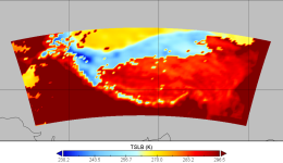
(1) The time period is the whole year of 2018, and I posted the results for a certain day in June. It can be seen that the soil temperature in the north is still the value at 0 o'clock on January 1st.
tslb.PNG
(2)
①About the area, my namelist is as follows
&domains
time_step = 180,
time_step_fract_num = 0,
time_step_fract_den = 1,
max_dom = 1,
e_we = 124, 112, 94,
e_sn = 56, 97, 91,
e_vert = 33, 33, 33,
p_top_requested = 5000,
num_metgrid_levels = 32,
num_metgrid_soil_levels = 4,
dx = 30000, 10000, 3333.33,
dy = 30000, 10000, 3333.33,
grid_id = 1, 2, 3,
parent_id = 0, 1, 2,
i_parent_start = 1, 31, 30,
j_parent_start = 1, 17, 30,
parent_grid_ratio = 1, 3, 3,
parent_time_step_ratio = 1, 3, 3,
feedback = 1,
smooth_option = 0
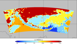
②About the landuse type, does it refer to LU_INDEX? If so, I think this may be the cause of the problem. It can be seen that in the north, LU_INDEX presents a similar situation to TSLB. Its value is 16, which represents land-ice? If this is the cause of the problem, I am curious why it only affects clm, and how can I correct it?
lu_index.PNG
 
CLM has its own landuse type. WPS takes USGS or MODIS as landuse in WRF. Later when wrf.exe starts with CLM, it rematches USGS/MODIS to CLM landuse. I am suspicious that this process may introduce some problems over the Tibetan Plateau.
Due to limited human power in NCAR, It is not our top priority to fix this issue over the specific region of Tibet. Please contact the developer (Dr. Jinming Jin, Utah University) for more help.
 
hi, everyone, I tried contacting the developer above, unfortunately no reply. So is it feasible for me to try and modify the code myself? Where should I start? If the process is too difficult, I can only ignore it for now.
 
Hi,
I am sorry to know that the developer didn't get back to you. It is not unusual because people are often overwhelmed by various issues.
In this case, I would encourage you to investigate this issue by your self, and I understand that it may take lots of time and efforts. Please keep us updated about the progress and let us know if you ave any questions during the process.
 
Top