wangchuanyang
New member
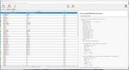
I use the Vtable.ERA-interim.pl Vtable to ungrib.exe, and then run metgrid.exe, it will create met_em.d.files, but the files donot have dimension called num_metgrid_levels or num_st_layers and num_sm_layers. If I use these files to run real.exe, there will be an error like:
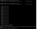
d01 2020-09-01_00:00:00 input_wrf.F: SIZE MISMATCH: namelist ide,jde,num_metgrid_levels= 80 80 34
d01 2020-09-01_00:00:00 input_wrf.F: SIZE MISMATCH: input file ide,jde,kde = 80 80 1
d01 2020-09-01_00:00:00 ---- ERROR: Mismatch between namelist and input file dimensions
NOTE: 1 namelist vs input data inconsistencies found.
or like:
----------------- ERROR -------------------
namelist : num_metgrid_soil_levels = 4
input files : NUM_METGRID_SOIL_LEVELS = 0 (from met_em files).
d01 2020-09-01_00:00:00 ---- ERROR: Mismatch between namelist and global attribute NUM_METGRID_SOIL_LEVELS
NOTE: 1 namelist vs input data inconsistencies found.
-------------- FATAL CALLED ---------------
FATAL CALLED FROM FILE: <stdin> LINE: 1254
NOTE: Please check and reset these options
-------------------------------------------
I believe the problem is in ungrib or metgrid, but I donot know how to solve it.
Here are the files: ungrib.log and metgrid.log.
Can anyone help me? Thank you!