I am using version 3.9.1 of WPS/geogrid and am trying to setup a 500-m grid-spacing domain across the US Midwest. Geogrid runs just fine, but the output has some kind of patterned artifact of bad values running through the grids, especially HGT_M, which causes problems when I get the wrfinput_d01 file from real and a subsequent WRF crash.
Here is the &geogrid section of my namelist:
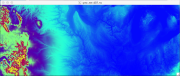
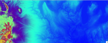
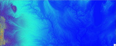
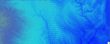
Additionally, I ran some sensitivity tests to see how bad this behavior was. I used the exact same &geogrid namelist code as above, but varied dx/dy across the following range of values: 100, 500, 750, 900, 999, 1000. Screenshots of HGT_M for all but the 999-m run are attached. Depending on how you want to look at it, the problem either gets worse with ever decreasing dx, or the artifact seems to gradually fade as you approach 999 or 1000 m DX.
[*]DX = 1000 m: Those familiar with Midwestern US geography will recognize this as being centered roughly on Iowa.

[*]DX = 900 m

[*]DX = 750 m

[*]DX = 500 m

[*]DX = 100 m: Obviously, by the time I get this fine in grid spacing, the artifact dominates the field so badly that it's pretty much unrecognizable.

So what is going on here, and how do I eliminate this behavior?
Here is the &geogrid section of my namelist:
&geogrid
parent_id = 1,
parent_grid_ratio = 1,
i_parent_start = 1,
j_parent_start = 1,
e_we = 2501,
e_sn = 1001,
geog_data_res = 'bnu_soil_30s+modis_15s_lakes+maxsnowalb_modis+albedo_modis+modis_lai',
dx = 500,
dy = 500,
map_proj = 'lambert',
ref_lat = 42.2,
ref_lon = -95.0,
truelat1 = 38.5,
truelat2 = 38.5,
stand_lon = -95.0,
geog_data_path = [omitted]
opt_geogrid_tbl_path = [omitted]
ref_x = 1250.0,
ref_y = 500.0,
Additionally, I ran some sensitivity tests to see how bad this behavior was. I used the exact same &geogrid namelist code as above, but varied dx/dy across the following range of values: 100, 500, 750, 900, 999, 1000. Screenshots of HGT_M for all but the 999-m run are attached. Depending on how you want to look at it, the problem either gets worse with ever decreasing dx, or the artifact seems to gradually fade as you approach 999 or 1000 m DX.
[*]DX = 1000 m: Those familiar with Midwestern US geography will recognize this as being centered roughly on Iowa.

[*]DX = 900 m

[*]DX = 750 m

[*]DX = 500 m

[*]DX = 100 m: Obviously, by the time I get this fine in grid spacing, the artifact dominates the field so badly that it's pretty much unrecognizable.

So what is going on here, and how do I eliminate this behavior?
