Hello WRF forum! 
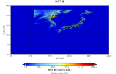
I have managed to import and use the SRTM 3s data as static topography data in my setup. However I have discovered behavior of geogrid that I am unsure is the correct behavior. The SRTM 3s data does not cover the entire model domain and thus when I use my namelist.wps I call the high resolution topography data as "geog_data_res = 'SRTM_3s+default'". The output of the of the HGT_M gives 0 everywhere else in the domain where the SRTM data does not exist. I was under the impression that geogrid interpolates between sources if one or more of the sources does not cover the entire domain, ie. it would populate the remaining area with the "default" source. However, it seems that geogrid looks if any data is present from the specified source in the domain and then use only that source; Is this the correct behavior of geogrid.exe? See the attached picture below:

My GEOGRID.TBL entries for the SRTM_3s:
My index file for the SRTM_3s:
I have managed to import and use the SRTM 3s data as static topography data in my setup. However I have discovered behavior of geogrid that I am unsure is the correct behavior. The SRTM 3s data does not cover the entire model domain and thus when I use my namelist.wps I call the high resolution topography data as "geog_data_res = 'SRTM_3s+default'". The output of the of the HGT_M gives 0 everywhere else in the domain where the SRTM data does not exist. I was under the impression that geogrid interpolates between sources if one or more of the sources does not cover the entire domain, ie. it would populate the remaining area with the "default" source. However, it seems that geogrid looks if any data is present from the specified source in the domain and then use only that source; Is this the correct behavior of geogrid.exe? See the attached picture below:

My GEOGRID.TBL entries for the SRTM_3s:
Code:
rel_path = SRTM_3s:topo_SRTM_3s/
interp_option = SRTM_3s:average_gcell(4.0)+four_pt+average_4pt
My index file for the SRTM_3s:
Code:
projection = regular_ll
known_x = 1.0
known_y = 18000.0
known_lat = 45.000000
known_lon = 120.000000
dx = 0.0008333334
dy = 0.0008333334
type = continuous
signed = yes
units = "meters MSL"
description = "Topography height"
wordsize = 2
tile_x = 6000
tile_y = 6000
tile_z = 1
tile_bdr = 0
missing_value = 32768
scale_factor = 1.000000
row_order = bottom_top
endian = little