Andrea-ARPAPUGLIA
Member
Dear all,
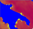
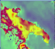
when i run the wrf (WRF 4.2.2 and WPS 4.2) using "corine 250" as land cover, the output of SST variable shows, along the coasts, strange square conformations (as shown in the attached figures). The TSK variable also shows the same strange conformations along the coast.
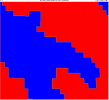
Instead when I use the standard land cover, the SST variable is not estimated in those squared regions (in the figure we used a different range of values).
Is this result normal or wrong? In the second case, how can it be avoided in order to obtain a uniform output over the whole sea?
Thank you for your reply.
when i run the wrf (WRF 4.2.2 and WPS 4.2) using "corine 250" as land cover, the output of SST variable shows, along the coasts, strange square conformations (as shown in the attached figures). The TSK variable also shows the same strange conformations along the coast.
Instead when I use the standard land cover, the SST variable is not estimated in those squared regions (in the figure we used a different range of values).
Is this result normal or wrong? In the second case, how can it be avoided in order to obtain a uniform output over the whole sea?
Thank you for your reply.