Scheduled Downtime
On Friday 21 April 2023 @ 5pm MT, this website will be down for maintenance and expected to return online the morning of 24 April 2023 at the latest

Too strong wind speed

This post was from a previous version of the WRF&MPAS-A Support Forum. New replies have been disabled and if you have follow up questions related to this post, then please start a new thread from the forum home page.

Hi,
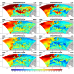
I am forcing WRF with ERA-Interim data for a real-case simulation over Europe. Compared to ERAI, I noticed the model simulates too strong surface wind speed (10m) over Gibraltar strait (please see attached for example). This issue then gets progressively worse in the nested domain.
I tried several different configurations changing the pbl, surface layer and surface physics parameterizations, but none of them produced the expected wind speed. Overall, I found the lowest bias with the present configuration (please see attached namelist); I wonder if there is something causing the problem and how can I fix it?

Any suggestions would be greatly appreciated.
 

Attachments

  • namelist.input
    6 KB · Views: 68
  • namelist.wps
    876 bytes · Views: 39
  • WRF-ERAI_WS.png
    WRF-ERAI_WS.png
    700.2 KB · Views: 1,711
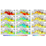
  • WRF-ERAI_WS_MED.png
    WRF-ERAI_WS_MED.png
    451.4 KB · Views: 1,709
Hi,
We are aware of the overestimation of surface wind speeds in WRF. To correct the bias, please set

topo_wind = 1, 1, 1 (in &physics)

Then rerun your case and see whether this is helpful.
 
Please make sure your input data includes var_sso, which is derived from static data. If you don't have this variable in wrfinput, you will need to rerun WPS.
 
Hi Ming,
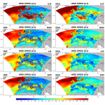
thanks for the prompt reply and suggestions. I re-did the simulation adding topo_wind = 1 (var_sso was already in wrfinput) and unfortunately results are even worse with strong winds popping up over high elevation areas (please see attached file). Is there anything else I can do to remove the bias over Gibraltar strait, excluding nudging?

Alessandro
 

Attachments

  • WRF-ERA5_WS_Europe.png
    WRF-ERA5_WS_Europe.png
    735.5 KB · Views: 1,701
Alessandro,

People in WRF group are aware of the overestimate of surface winds. The bias could be large or small depending on specific cases. We introduced topo_wind with the hope to mitigate the problem, and apparently it doesn't work as expected.

There is no other namelist option to control this problem. I am thinking whether you can increase roughness over the areas with large wind bias and hope somehow that might suppress the bias. I do understand that this will involve coding works and I am not sure whether that is practical for you.

Please keep me updated if you make progress in this issue. Thanks.
 
Hi Ming,
I tried to increase roughness length over ocean and this reduces the bias.
Now I would modify this value locally only in a few points around the Gibraltar strait; following this post (https://forum.mmm.ucar.edu/phpBB3/viewtopic.php?f=44&t=9799) should I only change module_sf_sfclayrev.F?
Alessandro
 
Dears,
I'm facing similar issue with overestimation error on 10m wind both on land and sea.
I decided to simply double the coefficient CZO to reduce my BIAS. I modified CZO into module_sf_sfclayrev.F, since I selected sf_sfclay_physics =2 by namelist
However when I plot the results on 10m wind, no changes show up
What am I doing wrong?
Thanks
 
If you run with the option sf_sfclay_physics = 2 (MYJSFCSCHEME), you need to modify the code "phys/module_sf_myjsfc.F". Detailed introduction of this surface scheme can be found in the following publications:

Janjic, Z. I., 1994: The step-mountain Eta coordinate model: further developments of the convection, viscous sublayer and turbulence closure schemes. Mon. Wea. Rev., 122, 927–945. doi:10.1175/1520-0493(1994)122<0927:TSMECM>2.0.CO;2

Janjic, Z. I., 1996: The surface layer in the NCEP Eta Model. Eleventh conference on numerical weather prediction, Norfolk, VA, 19–23 August 1996. Amer Meteor Soc, Boston, MA, pp 354–355.

Janjic, Z. I., 2002: Nonsingular implementation of the Mellor-Yamada Level 2.5 Scheme in the NCEP Meso model. NCEP Office Note No. 437, 61 pp.
 
Dear Ming,
big thanks. I actually understood module_sf_myjsfc.F is the routine to be modified and I did it.
My doubt is if what you suggest is just to multiply the roughness length by a constant value on the ocean grid points (ad/or land grid points) or if there is a high level approach I can follow
Thanks
Giorgia
 
Giorgia,
I think increasing the surface roughness length is the approach that you should follow. Please try and see how it works. Other variables involved in wind speed are calculated during the model integration and I don't think it is practical to modify them every time step.
 
Top