Scheduled Downtime
On Friday 21 April 2023 @ 5pm MT, this website will be down for maintenance and expected to return online the morning of 24 April 2023 at the latest

TSK field in wrfinput

This post was from a previous version of the WRF&MPAS-A Support Forum. New replies have been disabled and if you have follow up questions related to this post, then please start a new thread from the forum home page.

davidwrf

Member
Hi,

Hope this is the appropriate place for the question...

I'm using, separately, GFS 0.25ded and ECMWF 0.1deg data to initiate (two separate) WRF 4.1.2 simulations.
When plotting the TSK fields from wrfinput I have encountered with the following strange observation:
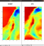
For the GFS-based setting, the TSK field seems much more detailed than the TSK field obtained with the ECMWF-based setting.
In the latter, the TSK field is much more homogeneous and smooth (as if it captures less the topography...).
The same holds for the SST field.

What could be the reason?


David
 
Hi,
Thanks for the answer.

I doubt that this is an issue of masking, for two reasons:
1. I use the same metgrid setting for the two simulation trial (that based on GFS and that based on ECMWF).
2. The phenomenon appears inland. Far from water bodies.

It is also strange that the better (more resolved) field is obtained with the GFS 0.25deg, and the less good field
is obtained with the ECMWF 0.1deg.

It is as if for the GFS the TSK field "captures" and follows the fine structure of the terrain, whereas for the ECMWF it does not.

David
 
David,
Can you send me one each of the input data files, along with your namelist.wps and namelist.input so that I can try to repeat this here? If the data files are too large, see the home page of this forum for information on attaching large files. Thanks!
 
Hi,
Thanks.
I have uploaded a tar.gz with the required files, with the "Attachments" option below.
I guess you should change in namelist.wps the geog_data_res flags to your own strings (to use, for example, the gtopo_30s topography or so...).

By the way, when trying to follow the instructions in the homepage, I could not get a link for the uploaded tar.

David
 

Attachments

  • to_tar.gz
    233.3 MB · Views: 25
David,
Thanks for sending this. I apologize for the delay. We are a little short on resources lately. I will check this out and get a response to you soon. Thank you for your patience!
 
Ok, again thanks for sending those and for your patience. I ran simulations with both of your input files. I see what you're referring to, though this difference in resolution occurs prior to running real. I see the same thing in the met_em* files, which should just be showing exactly what is in the first-guess (gfs and ecmwf) input files. Can you try to plot SKINTEMP from the original gfs and ecmwf files to see what that looks like?
 
Thanks a lot for checking that!

Yes, I can look at the TSK fields from the grib files.
I printed them for ECMWF and GFS for a similar region.
Please see the attached file.
In fact, the ECMWF TSK looks better.

What does it mean with respect to the WRF "digestion" of the data?

David
 

Attachments

  • ECvsGFS_grib_TSK.jpg
    ECvsGFS_grib_TSK.jpg
    147.1 KB · Views: 506
Hi David,
I wonder if this is because you seem to be missing a LANDSEA mask field in your input data for ECMWF. Take a look at this list of mandatory data and make sure you have everything you need.
 
Hi,
I'll check that.
Is it reasonable that the absence of the LANDSEA mask affects that much the inland areas?

In the grib file, the inland TSK for ECMWF looks better than that for GFS (as seen in the picture I sent).
But in met_em and wrfinput, the ECMWF TSK looks less good than that of GFS.
Can this be a result of an absence of the landsea mask in the EC data?

David
 
As @kwerner suggested, I think the significant differences in the SKINTEMP field after metgrid may be due to the use of the GFS LANDSEA field when horizontally interpolating the GFS skin temperature field, while no masked interpolation takes place for ECMWF due to the lack of a LANDSEA field in the ECMWF intermediate file. As a test, you could try commenting-out the lines in the SKINTEMP entry in the METGRID.TBL file that apply masked interpolation:
Code:
========================================
name=SKINTEMP
mpas_name=skintemp
        interp_option=sixteen_pt+four_pt+wt_average_4pt+wt_average_16pt+search
#        masked=both
#        interp_land_mask  = LANDSEA(1)
#        interp_water_mask = LANDSEA(0)
        fill_missing=0.
========================================
Regarding the question of how the masked interpolation can affect areas that are far inland, I think the key point is that the source mask is the LANDSEA field at the resolution of the GFS data (with the destination mask being the high-resolution LANDMASK field produced by the geogrid program). For a 1- or 2-point interpolation stencil, and a GFS resolution of 0.25 degrees, the source mask (LANDSEA) could affect points in the WRF grid approximately 27 to 54 km (0.25 or 0.50 degrees) away from land-sea boundaries (as resolved by the GFS).
 
Top