Hi,
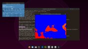
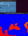
I am fourth grade meteorology student in Istanbul Technical University and I am running a high resolution (4km) WRF simulation with (sst_update=1) ERA5 IBC over Black Sea basin for three month period and the problem that i am facing with is the SST and LANDSEA fields are not matching with each other. Thus it causes crazy air temperature over coasts when i use default METGRID.TBL (attached as 2mtemp.jpeg and sst.jpeg)
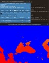
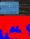
I've edited the METGRID.TBL with various options for SST field and you can see the results i've attached. I'd like to point that opt2.jpeg settings are interpolating the SST (I guess) to rivers (Dnieper) that flowing to Black Sea from Russia and Ukraine, as a result this affects the air temperature etc. around rivers. Next, I've tried op1.jpeg settings and the SST fields are acceptable for me but i wonder is there any better solution for this case? Thanks in advance
opt1.jpeg options
name=SST
interp_option=sixteen_pt+four_pt+wt_average_4pt
fill_missing=0.
missing_value=-1.E30
flag_in_output=FLAG_SST
interp_land_mask = LANDSEA(1)
masked=land
opt2.jpeg options
name=SST
interp_option=sixteen_pt+four_pt+wt_average_4pt+wt_average_16pt+search
fill_missing=0.
missing_value=-1.E30
flag_in_output=FLAG_SST
interp_land_mask = LANDSEA(1)
masked=land

