Dear Sir or Madam,
I'm running WRF in year 2023, and trying to update land use data with MODIS/061/MCD12Q1. I'm using polar stereographic projection, my namelist.wps is shown below. I have changed my GEOGRID.TBL, and cci2023 refers to the modis data.
```
&share
wrf_core = 'ARW',
max_dom = 1,
start_date = '2023-02-28_18:00:00','2019-08-03_00:00:00',
end_date = '2023-11-01_06:00:00','2019-09-04_12:00:00',
interval_seconds = 21600
io_form_geogrid = 2,
/
&geogrid
parent_id = 1, 1,
parent_grid_ratio = 1, 3,
i_parent_start = 1, 53,
j_parent_start = 1, 25,
e_we = 200, 220,
e_sn = 200, 214,
geog_data_res = 'cci2023+default','cci2020+default',
dx = 108000,
dy = 108000,
map_proj = 'polar',
ref_lat = 90.00,
ref_lon = -98.00,
truelat1 = 45.0,
truelat2 = 1.0,
stand_lon = -98.0,
geog_data_path = '/data8/huangty/geog_total'
/
&ungrib
out_format = 'WPS',
prefix = 'GFS',
/
&metgrid
fg_name = 'GFS'
io_form_metgrid = 2,
/
```
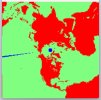
However, when I check the geo_em.d01.nc, I found out that in LANDUSEF and LANDMASK, there is something weird. Here is the picture produced by ncview showing the result of LANDMASK.

At first, my modis data is not complete, with the range of 85°S and 85°N and -179°W to 179°E. In this case, it may make sense that there is no data around 90°N and 180°E. But when trying to fix the problem, I download the modis data with full range, gdalinfo always shows that
```
Upper Left (-180.0044166, 90.0022083) (180d 0'15.90"W, 90d 0' 7.95"N)
Lower Left (-180.0044166, -90.0022083) (180d 0'15.90"W, 90d 0' 7.95"S)
Upper Right ( 180.0044166, 90.0022083) (180d 0'15.90"E, 90d 0' 7.95"N)
Lower Right ( 180.0044166, -90.0022083) (180d 0'15.90"E, 90d 0' 7.95"S)
Center ( 0.0000000, 0.0000000) ( 0d 0' 0.01"E, 0d 0' 0.01"N)
```
which surpasses 180° in longitude and 90° in latitude, while geogrid.exe cannot deal with those surpassing data either. Is there anything I can do to fix it?
Thanks,
Tim
I'm running WRF in year 2023, and trying to update land use data with MODIS/061/MCD12Q1. I'm using polar stereographic projection, my namelist.wps is shown below. I have changed my GEOGRID.TBL, and cci2023 refers to the modis data.
```
&share
wrf_core = 'ARW',
max_dom = 1,
start_date = '2023-02-28_18:00:00','2019-08-03_00:00:00',
end_date = '2023-11-01_06:00:00','2019-09-04_12:00:00',
interval_seconds = 21600
io_form_geogrid = 2,
/
&geogrid
parent_id = 1, 1,
parent_grid_ratio = 1, 3,
i_parent_start = 1, 53,
j_parent_start = 1, 25,
e_we = 200, 220,
e_sn = 200, 214,
geog_data_res = 'cci2023+default','cci2020+default',
dx = 108000,
dy = 108000,
map_proj = 'polar',
ref_lat = 90.00,
ref_lon = -98.00,
truelat1 = 45.0,
truelat2 = 1.0,
stand_lon = -98.0,
geog_data_path = '/data8/huangty/geog_total'
/
&ungrib
out_format = 'WPS',
prefix = 'GFS',
/
&metgrid
fg_name = 'GFS'
io_form_metgrid = 2,
/
```
However, when I check the geo_em.d01.nc, I found out that in LANDUSEF and LANDMASK, there is something weird. Here is the picture produced by ncview showing the result of LANDMASK.

At first, my modis data is not complete, with the range of 85°S and 85°N and -179°W to 179°E. In this case, it may make sense that there is no data around 90°N and 180°E. But when trying to fix the problem, I download the modis data with full range, gdalinfo always shows that
```
Upper Left (-180.0044166, 90.0022083) (180d 0'15.90"W, 90d 0' 7.95"N)
Lower Left (-180.0044166, -90.0022083) (180d 0'15.90"W, 90d 0' 7.95"S)
Upper Right ( 180.0044166, 90.0022083) (180d 0'15.90"E, 90d 0' 7.95"N)
Lower Right ( 180.0044166, -90.0022083) (180d 0'15.90"E, 90d 0' 7.95"S)
Center ( 0.0000000, 0.0000000) ( 0d 0' 0.01"E, 0d 0' 0.01"N)
```
which surpasses 180° in longitude and 90° in latitude, while geogrid.exe cannot deal with those surpassing data either. Is there anything I can do to fix it?
Thanks,
Tim
