shahbaz757
Member
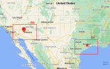
Hi, I am trying to create 2 domains for 2 different locations within one outer domain. (see picture)

I am using I and J coordinate values for the location in tslist file.
example-
tslist and tslist_gridIJ are identical tslist_latlon
#-----------------------------------------------# #-----------------------------------------------#
# 24 characters for name | pfx | I | J | # 24 characters for name | pfx | LAT | LON |
#-----------------------------------------------# #-----------------------------------------------#
Moerdijk_Solar s_m00 228 124 Moerdijk_Solar moerd 58 45
For converting longitude and latitude to coordinate I am using wrf.ll_to_xy() function from the wrf-python library. This requires a netCDF file, lat, long as the input,
Previously When I was using only two domain (one inner and one outer) I was using the netCDF file of inner domain to get the I and j coordinates values.
But now I am confused as to which domain netCDF file should I use to get the I and J coordinates? outer? inner D2? inner D3?
Please help me with this. Thank you
