Hi all,
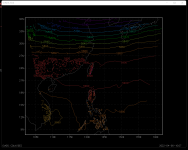
Recently, I used WRFV4 1.5 simulating Typhoon Megi (2010). Lambert projection is used in the experiment, and the horizontal resolution is 5km. The ERA5 Reanalysis products provides the initial field of the model. I compared the reanalysis data with the results of the first time of the model output. Among them, the distribution of air temperature, specific humidity and wind field is basically similar, but the distribution of geopotential height(ght) field is different. Whether over the land or over the sea, the value of the ght at the initial time of WRF output is greater than the reanalysis data (500hPa isobaric surface is about 20m larger), and there are abundant messy contours in the land area. I wonder where this error comes from, how to solve this problem, and whether these departures can have a great impact on the experimental simulation results?
Can anyone help me?
Thank you!

