Scheduled Downtime
On Friday 21 April 2023 @ 5pm MT, this website will be down for maintenance and expected to return online the morning of 24 April 2023 at the latest

WPS problem_NLCD 2011 data

Hello,

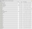
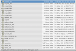
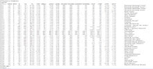
1. I ran WPS-4.4.2 over Charlotte, USA, to produce geo_em files using NLCD 2011 data. However, the log file shows that some data from the NLCD 2011 data were not available. I attached the namelist.wps, log file and static data list (images) in my directory.
Why is this problem happening?

2. When I plotted LULC values from the geo_em file created by using the attached namelist options...I found that LULC values are different for v-3.9.1 and v-4.4.2. I attached a figure to show the discrepancies. To my understanding, as I am using NLCD 2011 in both cases, they should be the same. Is there any version change or underlying process that is causing the difference?

Any help would be appreciated.

Thanks!
 

Attachments

  • Capture1.PNG
    Capture1.PNG
    373.5 KB · Views: 21
  • Capture2.PNG
    Capture2.PNG
    384.5 KB · Views: 15
  • Capture3.PNG
    Capture3.PNG
    329.1 KB · Views: 19
  • geogrid.log
    67.1 KB · Views: 6
  • lulc_compare.png
    684.1 KB · Views: 11
  • namelist.wps
    999 bytes · Views: 16
Hi,
When you say some of the data are not avialable, if you're referring to the lines, for e.g.,

Code:
2023-03-07 20:58:44.042 --- INFORM: For LAI12M, couldn't find interpolator sequence for resolution nlcd2011_9s.
2023-03-07 20:58:44.042 --- INFORM: Using default interpolator sequence for LAI12M.
2023-03-07 20:58:44.042 --- INFORM: For LAI12M, couldn't find nlcd2011_9s data source.
2023-03-07 20:58:44.042 --- INFORM: Using default data source for LAI12M.
2023-03-07 20:58:44.044 --- INFORM: For SNOALB, couldn't find interpolator sequence for resolution nlcd2011_9s.
2023-03-07 20:58:44.044 --- INFORM: Using default interpolator sequence for SNOALB.

that is because these particular fields are not part of the NLCD dataset, and since you've asked geogrid to use nlcd2011_9s+default, it uses the nlcd data when it's available, and if not, it uses the default data (which are MODIS fields in V4 of WPS).

As for you question about LULC, what is that? That variable is not in any of the GEOGRID.TBL files or geo_em* output I am seeing.


Thanks for clarifying point 1.

For point 2,

LULC is the land use and land cover data. I plotted the "LU_INDEX" variable from the geo_em files in those images. For NLCD, there are 40 "LU_INDEX" values from 1 to 40, and each number is associated with a land use that I got from vegparm.tbl. When I plotted those, I found differences in "LU_INDEX" between the 2 versions' geo_em files.
 

Attachments

  • NLCD_vegparm.PNG
    NLCD_vegparm.PNG
    89.8 KB · Views: 20
Hi,
I ran a test using your namelist.wps file (so geog_data_res = 'nlcd2011_9s+default'), with WPSv4.4 and WPSv3.9.1 and LU_INDEX is identical in both of them. Could it be possible that you made some changes in one of them? Are you using the default GEOGRID.TBL for both? There are differences in the GEOGRID.TBL files between the two versions, but nothing that should interfere with these simulations.


I did not change anything :(. Is there anyway you can give me the geo_em files you created for both versions?
 
Yes, absolutely! I've uploaded the files into a single .tar package into our Nextcloud Drive. The file name is kwerner_geo_em_files.tar. When you unpack the tar file, you'll see the two directories (one for each WPS version) that contains the geo_em* files.
 
Yes, absolutely! I've uploaded the files into a single .tar package into our Nextcloud Drive. The file name is kwerner_geo_em_files.tar. When you unpack the tar file, you'll see the two directories (one for each WPS version) that contains the geo_em* files.


Thanks a lot for providing the files. I plotted them, and they match the right image (v4.4.2) from the previous figure (lulc_compare.png in the first post).

However, I identified that this is not a version issue. It is happening because of the static data. I attached this link, where you can see two folders. The older_data folder contains nlcd static data that was downloaded a long time ago by the HPC staffs at my university. The newer_data folder contains the most recent version of nlcd static data. I ran geogrid with these two data sets separately and plotted the geo_em files (lulc_compare_static_data.png). You can see the difference in both figures, which shows how much different the cells are in terms of land uses.

Now, my concern is that the NLCD 2011 land use data cannot vary over time or anything. Whether the code is updated or not, each cell should have the same land use value. I do not know which one is right or which one I should use.

Can you please look into it? Thanks!
 

Attachments

  • lulc_compare_static_data.png
    702.9 KB · Views: 12
Unfortunately we don't have a lot of information about the static datasets we receive. They are given to us by outside sources and are tested by other colleagues outside our group. I would advise that either you use the most-recently downloaded version, or perhaps contact a support person who manages the NLCD data to determine the best answer.
 
Top