Good morning support team.
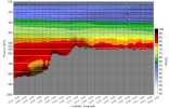
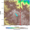
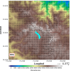
I am processing the outputs of the WRF model using the wrf-python package. Making an analysis of the diurnal surface wind cycle (wind10), Figure_02, the results are consistent with previous studies and empirical observations. With flows from the valleys (lowlands, north-east part) to the mountains (highlands) during the day. However, when doing the same analysis of a vertical section (red line, Figure_01) with the wind data (3D), figura_01, the wind flow on the surface is from the highlands to the lowlands in the north part of the vertical s ection, this does not agree with the results on the surface. To process the 3D wind data and perform the vertical section I have used the following wrf-python functions:
p = getvar(fo, "pressure")
data_var = getvar(fo, var_name)
df_var_cross = vertcross(data_var, p, wrfin=fo, start_point=start_point,
end_point=end_point, latlon=True, meta=True)
Please, I want to know if using the functions getvar and vertcross are enough to do the transformation of the 3D winds, or is it necessary to do some kind of additional transformation for the southern hemisphere, where the study area is located.
Thanks for your help.
All the best.


