Hi, I am using the Thompson aerosol-aware MP scheme (MP option=28) in WRFv4.1.2 and WPS 4.1 for a real-case simulation over southcentral Canada. I have two domains in my simulation and I am using the 12-km NAM analysis as my meteorological forcing dataset. I downloaded the climatological aerosol input dataset from https://www2.mmm.ucar.edu/wrf/users/wrfv3.9/mp28_updated.html and followed the instructions to set up my namelist.wps and namelist.input files for this scheme option (please see attached). I was able to run geogrid.exe, ungrib.exe, and finally metgrid.exe to get the met_em files in WPS. I could see I_WIF_month*, W_WIF_month*, and P_WIF_month* variables in my met_em files, which should mean that the climatological aerosol dataset was correctly ingested into my met_em files. Then I ran real.exe and was able to get wrfinput files for both domains and wrfbdy_d01. Finally, I ran my simulation with wrf.exe and wrfout_d0* files were produced for both domains.
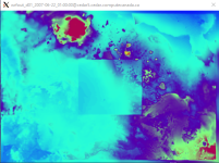
However, when I checked the QNWFA variable in my wrfout_d01 files some time into my simulation, I noticed something went wrong in the QNWFA field. A box denoting my inner nested domain is clearly visible when visualizing the output from the wrfout_d01 files using ncview (please see attached for example). If working properly, I should see a smooth transition going from d01 to the inner nested domain d02 (i.e, no visible box). Upon further inspection, I found that the QNWFA2D variable (surface aerosol number concentration emission) is the likely source of the problem. For some reason, the magnitude of this variable in the inner nested domain is almost an order of magnitude smaller than that in the surrounding parent domain. Therefore, after some model integration time, the low-level QNWFA over areas covered by d02 is significantly lower (not zero though) than that in the surrounding d01 domain, hence the "box" feature when visualizing my wrfout_d01 files. If I have three domains, the problem would get progressively worse in each successive nested domain. That is, the QNWFA2D variable in d03 is another order of magnitude smaller than that in d02 (therefore, two-orders of magnitude smaller than that in d01). The same problem also exists when I use the use_aero_icbc = .false. option. I have attached a PDF file below that demonstrates this issue. The other variable produced by the Thompson aerosol-aware scheme, QNIFA, looks fine in my output files though, but it may be due to the fact that QNIFA2D is zero at all times.
I updated my WRF version to WRFv4.2.1 and WPS version to WPSv4.2 to see if this problem has been resolved, but it still exists in the newer version. I did, however, modify my GEOGRID.TBL.ARW to make geogrid.exe work better with my application in both versions of WRF and WPS. I wonder if that's what's causing the problem. I thought that METGRID.TBL was the only relevant file for this portion (metgrid.exe) of WPS.
Did I make a mistake during my model set up or there was a bug in the WRF source code? Any suggestions would be greatly appreciated.