george_victor
New member
Hi!
I was making 2 sensitivity WRF simulations over ICE COVERED OCEAN. The focus was on atmosphere-ocean boundary layer.
Following details/parameterizations were kept same for both simulations:
The duration of simulation was 2 days.
There were 4 domains nested one over the other. Resolutions of 4th and 3rd domains are 80m and 240m respectively.
Physics parameterizations used are same for both simulations.
The only difference between 2 simulations is that the input data for SEAICE concentration was modified.
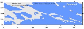
In the first sensitivity simulation, inside domain 4, the SEAICE concentration (input data) values were either 1 (which mean ice) or 0 (which means open water). There are no intermediate values used (eg: 0.2, 0.3 etc). This means, it is either fully ice covered grid, or it is fully open water region.
In the second simulation, the SEAICE concentration values (input data) were uniform for entire domain 4. The value was 0.3 for all grid points. This means the grid is neither fully open water, nor is it fully ice covered.
I was successful in generating 10m-winds with reasonable accuracy in both cases.
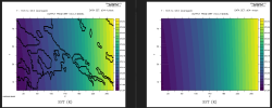
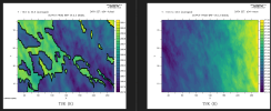
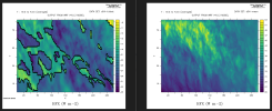
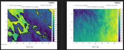
However, in the first simulation, the 2m temperature (T2) and potential temperature at 2m (TH2) over sea ice grids were higher than the surrounding open water grids. According to my understanding, both T2 and TH2 are dependent on the surface temperatures. Now, considering that the surface temperatures over SEAICE is lower than that over the open water, the values of T2 and TH2 should've been lower over SEAICE grids.
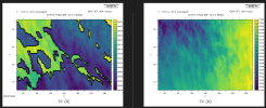
Another concern I've is that, the model estimated heat fluxes (HFX) were positive values for the second simulation. The postive sign is expected to represent the direction, and positive means upward direction. However, in the first simulation, HFX values ranged in negative values irrespective of whether it is over SEAICE or over open water.
Why am I seeing such behaviours? Can someone please address this .
Few time averaged spatial (domain 4) figures are attached for reference. For each figure, the left hand side show the first simualtion and right hand side show the second simulation.
Here is the physics parameterization that I used:
&physics
physics_suite = 'CONUS'
mp_physics = -1, -1, -1, -1,
cu_physics = 0, 0, 0, 0,
ra_lw_physics = -1, -1, -1, -1,
ra_sw_physics = -1, -1, -1, -1,
bl_pbl_physics = 4, 4, 4, 0,
sf_sfclay_physics = 4, 4, 4, 4,
sf_surface_physics = 4, 4, 4, 4,
radt = 10, 10, 10, 10,
bldt = 0, 0, 0, 0,
cudt = 5, 5, 5, 0,
icloud = 1,
num_land_cat = 21,
sf_urban_physics = 0, 0, 0, 0,
num_soil_layers = 4,
surface_input_source = 1,
fractional_seaice = 1,
seaice_thickness_opt = 0,
seaice_thickness_default = 1.2,
seaice_albedo_opt = 1,
seaice_snowdepth_opt = 0,
seaice_snowdepth_min = 0,
seaice_snowdepth_max = 2,
tice2tsk_if2cold = .true.,
isfflx = 1,
ifsnow = 0,
Thank you in advance.


