Scheduled Downtime
On Friday 21 April 2023 @ 5pm MT, this website will be down for maintenance and expected to return online the morning of 24 April 2023 at the latest

dveg option for NOAH-MP LSM

Alessandro Delo

New member
Dear all,

I'm running several exps with WRF (v. 4.4.1) + WRF-HYDRO (v. 5.2) and I'm facing some issues related to the evaluation of the 2 meter temperature in a specific region of Europe (Balkan area in details). My simulations show a difference of more than 10˚ over this region with respect ERA5 dataset. I suspect it is something related to the LAI (Leaf area index) parameter. I'm trying to do a bit of sensitivity about the dveg option that can be used within NOAHMP LSM. Reading the WRF userguide, there are several choices that one can do related on how to set the dveg option in the WRF namelist:
- "lai predicted" (options 2 e 5): we are activating a model, within NOAMP, related to the vegetation;
- "lai from table" (options 1 and 3, maybe 7, 8 and 9), reads this variable from Table.
- "lai from input" (options 7, 8 e 9): takes monthly LAI from geo_em (I/m actually using MODIS dataset, 30arcsec resolution).

To me, it is not clear enough the difference between the options "Lai from table" and "Lai from input". Can someone help me to fully get this point? Which is the difference between them?

Many many thanks in advance!

Alessandro
 
Alessandro,

If "Lai from table", it means that LAI will be read from VEGPARM.TBL based on land use type

if ""Lai from input"", it indicates that the model will suit LAI from static data.

The nameliust option "rdlai2d" determines which option will be used.

rdlai2d = .false. ! use LAI from input; false means using values from table
 
Hi Ming,
thank you very much for your precious and very explicative message! Now everything is clear.
We missed to include, in the WRF namelist, the "rdlai2d" option, so I fear we have run all our experiments performed till now without taking LAI from input files (MODIS dataset), even if devg option=7 was activated. I already submitted a new run by adding the option you suggested us: it should work now!

I'll update you when the run will finish!

Thank you very much again!

Alessandro
 
Dear Ming, dear all,

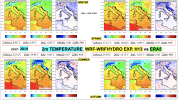
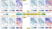
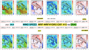
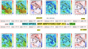
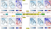
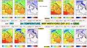
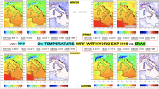
I just finished to validate the results of my last exp by adding the voice in the namelist you suggested me last time (rdlai2d set to true), so to consider LAI from input files (dveg option =7 for NOAH-MP LSM). I compared my results with ERA5 dataset for T2M (but also for rainfall and wind speed). The exp refers to 2019. Unfortunately, I was not able to obtain a sensible improvement for T2M, the issue I evidenced last time over the Balkan region still remains evident. I attach 2D lat/lon seasonal maps I produced so you can have an idea on what I'm referring to. I'm also facing a strong underestimation of rainfall.
I attach also the namelist I'm using to run my exps (the one I'm sending is referred to a 30 days simulation), maybe you/somebody can have a look and could suggest me something to improve my results. I fear I'm missing something there (i.e, not using the proper physical parameterization or, maybe, some static fields are not good enough for my region of interest, even if I'm using the latest ones available and downloadable for WRF website). The version of WRF I'm using is 4.4.1, WRF-HYDRO is 5.2.0.

Thank you very much in advance for your help!

Alessandro
 

Attachments

  • T2m_2019.png
    T2m_2019.png
    3 MB · Views: 9
  • rainfall_2019.png
    rainfall_2019.png
    3.6 MB · Views: 9
  • wind_speed_2019.png
    wind_speed_2019.png
    3.4 MB · Views: 10
  • namelist_input_1.txt
    6.6 KB · Views: 14
Hi Alessandro,
I looked at your namelist.inout. Both the physics and dynamic options look appropriate.
The only concern I have is the resolution of your case. Note that cumulus scheme works fine for grid interval larger than 10km, and it should be turned off when grid interval is smaller than 3-4km. The resolution between 4-10km is the so called grey-zone, over which cumulus scheme no longer woks fine yet the convection cannot be well resolved. In your case, delx = 6km, and I would suggest you run with and without cumulus scheme, then compare the results and see which can give you better results.
 
Hi Ming,
thank you very much for your prompt reply.
I submitted a new exp by following your suggestions (i.e. deactivating cumulus scheme, cu_physics =0), I'll let you know the results.

In the meanwhile, I would share with you the list of the static fields I'm using for my exps, maybe the issues I evidenced are related to them.

  1. BNU SoilType bottom
Improved worldwide soiltype (BNU = Beijing Normal University) https://agupubs.onlinelibrary.wiley.com/doi/full/10.1002/2015JD024558
  1. BNU SoilType top
Improved worldwide soiltype (BNU = Beijing Normal University) https://agupubs.onlinelibrary.wiley.com/doi/full/10.1002/2015JD024558
  1. MODIS Greenfraction
Change dveg in NOAH_MP sec (dveg=7)
  1. MODIS LAI 30s
Change dveg in NOAH_MP sec (dveg=7)
  1. Lake depth
used if lake model on (sf_lake_physics=1). Not our case since now
  1. Clayfrac
Used in Thompson MP scheme (mp_physics = 28) and WRF-CHEM
  1. Erod
Used in Thompson MP scheme (mp_physics = 28) and WRF-CHEM
  1. Irrigation data
NOTE: crop data available only CONUS (Crop data outside US)
  1. Bathymetry
Useful since V4.4. Option namelist.input shalwater_z0. see user guide
  1. Noah-MP specific dataset
Crop+ grounwater (water table height)+soilgrids.
NOTE: crop data available only CONUS (Crop data outside US)

The issues, especially the one related to 2mT, emerged when we moved from NOAH to NOAHMP LSM: indeed, with previous static fields (i.e. the ones used in WRF v. 3.5.1) with respect the ones here reported and by using NOAH, we did not face with such problems, even if we used some cumulus scheme (i.e. Tiedke or Kain-Fritsch).
The most significant change from NOAH and NOAH-MP seems the introduction of LAI in the calculations, that's why we are focusing our attention on that parameter. But maybe there is something else that we are not correctly evaluating...

Any idea/suggestion about the proper way to use Noah-MP options? What about LAI? Is our point of view correct?

Thank you in advance!

Alessandro
 
Alessandro,

Just a quick address to your concern:

I know that values in VEGPARM.TBL are different in different versions of WRF. These changes may lead to different model behaviors.

NoahMP is an update of Noah and we expect it can perform better than Noah. However, no systematic evaluation has been conducted and I suppose it is not always true since very often the model performance is case-dependent.
 
Hi Ming, Hi all,

thanks again for your help!

The experiment we run by deactivating the cumulus scheme performed worse than the one with a parameterization choose among the ones available, so in the following attempts we will continue to adopt a scheme for cumulus. We will test some of them to match the best one that works fine for our region.

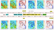
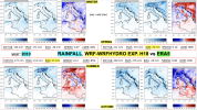
In the meanwhile, following your suggestions, we performed an experiment by using, as Land surface model, NOAH instead of NOAHMP (and by adopting exactly the same namelist options for the other keys, the one I attached you in a previous post). What we experienced, as regards T2m, is that we improved, with NOAH, our performances during spring and summer seasons with respect the run performed with NOAHMP. Also for wind speed we observed an improvement, especially over mountain regions. I attach you the seasonal maps collected for the two experiments I'm referring to (EXPH13 is the one with NOAHMP, EXPH18 the one with NOAH).

By comparing the maps, it seems that the issue with NOAHMP is mostly concentrated over mountain regions (Balkan area and Alps, in detail). So we are suspecting that, maybe, some options we are using for filling NOAHMP part of the namelist, are not working properly. We were now thinking about changing, in the next experiments, some of them to solve the problem over mountains, by tuning and testing the other available option for these keys:
- opt_alb: ground surface albedo option (now, default one we are using is 2: CLASS (Canadian Land Surface Scheme);
- opt_rsf: surface evaporation resistence option (1, Sakaguchi and Zeng, 2009);
- opt_rad: radiative transfer option (3, two-stream applied to veg fraction);
- opt_btr: soil moisture factor for stomatal resistance (1, Noah);
- opt_crs: surface layer drag coefficient calculation (1, Monin-Obukhov).

According to your experience, which of them is the one that is mostly influencing the mountain regions? I know it's very difficult to detect only one factor as the responsible of this behavior, but maybe among the one previously mentioned there is the "guilty".

Regards,
Alessandro
 

Attachments

  • WIND_SPEED_10m_2019_EXPH18_NOAH.png
    WIND_SPEED_10m_2019_EXPH18_NOAH.png
    3.4 MB · Views: 7
  • RAIN_2019_EXPH18_NOAH.png
    RAIN_2019_EXPH18_NOAH.png
    3.1 MB · Views: 3
  • WIND_SPEED_10m_2019_EXPH13_NOAHMP.png
    WIND_SPEED_10m_2019_EXPH13_NOAHMP.png
    2.8 MB · Views: 3
  • RAIN_2019_EXPH13_NOAHMP.png
    RAIN_2019_EXPH13_NOAHMP.png
    2.9 MB · Views: 4
  • T2m_2019_EXPH13_NOAHMP.png
    T2m_2019_EXPH13_NOAHMP.png
    2.5 MB · Views: 3
  • T2m_2019_EXPH18_NOAH.png
    T2m_2019_EXPH18_NOAH.png
    2.7 MB · Views: 5
Top