Hi forum,
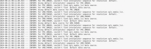
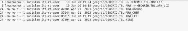
I have been trying to use the CGLC_MODIS_LCZ data. When I re-linked the GEOGRID.TBL with GEOGRID.TBL.AWR_LCZ, and run the geogrid.exe it shows the error(geogrid.log):
INFORM: For LANDUSEF, couldn't find interpolator sequence for resolution default.
but when I delete the content about CGLC_MODIS_LCZ, the geogrid.exe excecuted successfully.
I also tried to add entries to the original LANDUSEF section like this (screen shot attached):
the geogrid.exe worked but the final geo_em.d04.nc only have 21 categories instead of 61.
The WPS V4.5 is used.
Could you please take a look at it? Thanks.
Best,
Tony