Scheduled Downtime
On Friday 21 April 2023 @ 5pm MT, this website will be down for maintenance and expected to return online the morning of 24 April 2023 at the latest

Issue with Custom Land Use Data (BIL) Not Being Applied in geogrid.exe

aba0327

New member
I am trying to use a custom EGIS Land Use dataset for WRF-UCM by converting it into a binary (BIL) file. However, after running geogrid.exe, the generated geo_em.d03.nc file does not reflect my custom dataset, and LU_INDEX remains at 17 across the entire domain.

Steps I Followed:

  1. Converted an EGIS shapefile to raster using Python (rasterio).
  2. Saved it as a BIL filewith EHdr format (8-bit categorical).
    • Python:
      ds["MODIS_CODE"] = ds["MODIS_CODE"].astype(np.uint8)
      ds = ds.to_crs("EPSG:4326")
      
      resolution = 0.00083333
      
      bounds = ds.total_bounds
      left, bottom, right, top = bounds
      
      width = int((right - left) / resolution)
      height = int((top - bottom) / resolution)
      
      raster_array = np.full((height, width), 0, dtype=np.uint8)
      
      shapes = [(geom, value) for geom, value in zip(ds.geometry, ds["MODIS_CODE"])]
      
      rasterized = rasterize(
          shapes,
          out_shape=(height, width),
          transform=from_origin(left, top, resolution, resolution),
          fill=0,
          dtype=np.uint8
      )
      
      binary_output = "./EGIS_LANDUSE.2023.v8/EGIS_LANDUSE.bil"
      
      with rasterio.open(
          binary_output,
          "w",
          driver="EHdr",
          width=width,
          height=height,
          count=1,
          dtype=np.uint8,
          crs="EPSG:4326",
          transform=from_origin(left, top, resolution, resolution),
      ) as dst:
          dst.write(rasterized, 1)
  3. Configured GEOGRID.TBLto reference my dataset (egis_landuse).
    • INI:
      name=LANDUSEF
              priority = 2
              dest_type = categorical
              z_dim_name = land_cat
              dominant = LU_INDEX
              landmask_water =  egis_landuse:17,21      # Calculate a landmask from this field
              interp_option =  egis_landuse:nearest_neighbor
              rel_path =   egis_landuse:egis_landuse/
  4. Ran geogrid.exe, and the log confirms that my dataset is being processed.
  5. Checked geo_em.d03.nc, but my land use data is not applied.

Verification Checks & Findings

  1. Endian Check:
    • Used od -An -t d1 00001-01890.00001-01200 | head -n 20
    • Values appear correctly stored as uint8 integers.
  2. Coordinate System Check:
    • ncdump -h geo_em.d03.nc | grep -i 'MAP_PROJ' → MAP_PROJ = 1 (Lambert Conformal Projection).
    • ncdump -h geo_em.d03.nc | grep -i 'DX\|DY' → DX = 0.00083333, DY = 0.00083333.
  3. BIL File Header & Data Integrity:
    • BIL file size matches expected dimensions.
    • hexdump -C shows diverse land use values.
    • row_order = top_bottom was confirmed in the metadata.

Problem & Observations:

  • geogrid.log confirms that egis_landuse is being processed.
  • However, in geo_em.d03.nc, LU_INDEX remains 17 across all points instead of reflecting EGIS data.
  • When using geog_res_path = egis_landuse+default, LU_INDEX is set to a single code (not reflecting EGIS values).
  • When using geog_res_path = default+egis_landuse, only the default dataset is applied.

Questions:

  1. Is using rasterio instead of GDAL causing an issue with the BIL file format?
  2. Does WRF require a specific Endian format for BIL files? How can I ensure my file is formatted correctly?
  3. Should I reproject my dataset to match WRF’s Lambert Projection instead of using EPSG:4326?
  4. How can I verify that geogrid.exe is correctly reading my binary file and not defaulting to MODIS?
  5. Are there specific settings in GEOGRID.TBL that must be changed to force egis_landuse to overwrite default land use data?
 
Apologies for the delay in response, and thank you for your patience. Are you still experiencing this issue? If so,

1) Have you plotted the landuse data from the input EGIS data to verify the landuse data is accurate in the input file?
2) Can you attach your namelist.wps file, geogrid.log, and the modified GEOGRID.TBL so we can take a look?
 
Dear kwerner,

Thank you for your response. I appreciate your help.

I am still experiencing the issue and have not yet been able to resolve it.

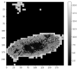
  1. I have converted the shapefile to a binary file and visualized the output. I have attached the visualization, where it appears that the land use codes have been correctly assigned. The regions with code 0 correspond to areas where no data was present in the original shapefile.1741842972753.png
  2. I have attached the requested files: namelist.wps, geogrid.log, and GEOGRID.TBL (land use-related sections only).
    • namelist.wps
    • geogrid.log
    • Modified GEOGRID.TBL: I have included only the land use-related sections. Other parts of the file remain unchanged.
      • INI:
        ===============================
        name=LANDUSEF
                priority = 2
                dest_type = categorical
                z_dim_name = land_cat
                dominant = LU_INDEX
                landmask_water =  egis_landuse:17,21      # Calculate a landmask from this field
                interp_option =  egis_landuse:nearest_neighbor
                rel_path =   egis_landuse:egis_landuse/
        name=LANDUSEF
                priority = 1
                dest_type = categorical
                z_dim_name = land_cat
                dominant = LU_INDEX
                landmask_water =    nlcd2006_9s:17         # Calculate a landmask from this field
                landmask_water =   nlcd2006_30s:17         # Calculate a landmask from this field
                landmask_water =    nlcd2011_9s:17         # Calculate a landmask from this field
                landmask_water =       nlcd2006:17         # Calculate a landmask from this field
                landmask_water =       ssib_10m:16         # Calculate a landmask from this field
                landmask_water =        ssib_5m:16         # Calculate a landmask from this field
                landmask_water =      modis_15s:17         # Calculate a landmask from this field
                landmask_water = modis_15s_lake:17,21      # Calculate a landmask from this field
                landmask_water =      modis_30s:17         # Calculate a landmask from this field
                landmask_water = modis_30s_lake:17,21      # Calculate a landmask from this field
                landmask_water =       usgs_30s:16         # Calculate a landmask from this field
                landmask_water =     usgs_lakes:16,28      # Calculate a landmask from this field
                landmask_water =    modis_lakes:17,21      # Calculate a landmask from this field
                landmask_water =     modis_2010:17         # Calculate a landmask from this field
                landmask_water = modis_2010_lake:17,21     # Calculate a landmask from this field
                landmask_water =     modis_2050:17         # Calculate a landmask from this field
                landmask_water = modis_2050_lake:17,21     # Calculate a landmask from this field
                landmask_water =        usgs_2m:16         # Calculate a landmask from this field
                landmask_water =        usgs_5m:16         # Calculate a landmask from this field
                landmask_water =       usgs_10m:16         # Calculate a landmask from this field
                landmask_water =         lowres:17,21      # Calculate a landmask from this field
                landmask_water =        default:17,21      # Calculate a landmask from this field
                interp_option =    nlcd2006_9s:average_gcell(0.0)
                interp_option =   nlcd2006_30s:average_gcell(0.0)
                interp_option =    nlcd2011_9s:average_gcell(0.0) 
                interp_option =       nlcd2006:nearest_neighbor
                interp_option =       ssib_10m:four_pt
                interp_option =        ssib_5m:four_pt
                interp_option =      modis_15s:nearest_neighbor
                interp_option = modis_15s_lake:nearest_neighbor
                interp_option =      modis_30s:nearest_neighbor
                interp_option = modis_30s_lake:nearest_neighbor
                interp_option =       usgs_30s:nearest_neighbor
                interp_option =     usgs_lakes:nearest_neighbor
                interp_option =    modis_lakes:nearest_neighbor
                interp_option =     modis_2010:nearest_neighbor
                interp_option = modis_2010_lake:nearest_neighbor
                interp_option =     modis_2050:nearest_neighbor
                interp_option = modis_2050_lake:nearest_neighbor
                interp_option =        usgs_2m:four_pt
                interp_option =        usgs_5m:four_pt
                interp_option =       usgs_10m:four_pt
                interp_option =         lowres:average_gcell(4.0)+four_pt
                interp_option =        default:nearest_neighbor
                rel_path =    nlcd2006_9s:nlcd2006_ll_9s/
                rel_path =   nlcd2006_30s:nlcd2006_ll_30s/
                rel_path =    nlcd2011_9s:nlcd2011_ll_9s/
                rel_path =       nlcd2006:nlcd2006_ll_30s/
                rel_path =       ssib_10m:ssib_landuse_10m/
                rel_path =        ssib_5m:ssib_landuse_5m/
                rel_path =      modis_15s:modis_landuse_20class_15s/
                rel_path = modis_15s_lake:modis_landuse_20class_15s_with_lakes/
                rel_path =      modis_30s:modis_landuse_20class_30s/
                rel_path = modis_30s_lake:modis_landuse_20class_30s_with_lakes/
                rel_path =       usgs_30s:landuse_30s/
                rel_path =     usgs_lakes:landuse_30s_with_lakes/
                rel_path =    modis_lakes:modis_landuse_21class_30s/
                rel_path =     modis_2010:slucm/modis_landuse_20class_15s_2010s/
                rel_path = modis_2010_lake:slucm/modis_landuse_20class_15s_2010s_with_lakes/
                rel_path =     modis_2050:slucm/modis_landuse_20class_15s_2050s/
                rel_path = modis_2050_lake:slucm/modis_landuse_20class_15s_2050s_with_lakes/
                rel_path =        usgs_2m:landuse_2m/
                rel_path =        usgs_5m:landuse_5m/
                rel_path =       usgs_10m:landuse_10m/
                rel_path =         lowres:modis_landuse_20class_5m_with_lakes/
                rel_path =        default:modis_landuse_20class_30s_with_lakes/
        ===============================
    • index: I am attaching the index file in case it might be useful for debugging.
      • type=categorical
        category_min=1
        category_max=21
        projection=regular_ll
        dx=0.00083333
        dy=0.00083333
        known_x=1.0
        known_y=1.0
        known_lat=34.0245836581763
        known_lon=126.142083298846
        wordsize=1
        row_order=top_bottom
        tile_x=1110
        tile_y=1000
        tile_z=1
        missing_value=0
        units="category"
        description="EGIS Landuse"
        mminlu="MODIFIED_IGBP_MODIS_NOAH"
        iswater=17
        islake=21
        isice=15
        isurban=13
Please let me know if you need any additional information. Thank you again for your support.

Best regards,
aba0327
 

Attachments

  • geogrid.log
    86.8 KB · Views: 1
  • namelist.wps
    950 bytes · Views: 4
Thanks for sending those. I'm not positive if this is causing the issue, but I believe the format on the GEOGRID.TBL is important, meaning that you will need to add the divider between the two LANDUSEF entries in your table. Currently, it's listed as:

Code:
===============================
name=LANDUSEF
        priority = 2
        dest_type = categorical
        z_dim_name = land_cat
        dominant = LU_INDEX
        landmask_water =  egis_landuse:17,21      # Calculate a landmask from this field
        interp_option =  egis_landuse:nearest_neighbor
        rel_path =   egis_landuse:egis_landuse/
name=LANDUSEF
        priority = 1
        dest_type = categorical
        z_dim_name = land_cat
        dominant = LU_INDEX
        landmask_water =    nlcd2006_9s:17         # Calculate a landmask from this field
        landmask_water =   nlcd2006_30s:17         #
        ...

Try adding the divider, as is shown below:

Code:
===============================
name=LANDUSEF
        priority = 2
        dest_type = categorical
        z_dim_name = land_cat
        dominant = LU_INDEX
        landmask_water =  egis_landuse:17,21      # Calculate a landmask from this field
        interp_option =  egis_landuse:nearest_neighbor
        rel_path =   egis_landuse:egis_landuse/
===============================
name=LANDUSEF
        priority = 1
        dest_type = categorical
        z_dim_name = land_cat
        dominant = LU_INDEX
        landmask_water =    nlcd2006_9s:17         # Calculate a landmask from this field
        landmask_water =   nlcd2006_30s:17         #
        ...

and then rerun geogrid and see if there is any difference. If not, will you package up your EGIS data and share it with me so I can test it out? If it's too large to attach to this thread, see the forum home page for instructions on sharing large files. Thanks!
 
Dear kwerner,

Thank you for your response again.

  1. Change TBL: I tried again as you said, but I got the following error message. I confirmed that the geogrid stopped without running. The geogrid.log had a value of 107.
    • Bash:
      ERROR: In GEOGRID.TBL, dominant category at entry 2 cannot have the same name as dominant category at entry 3. Abort(56052224) on node 0 (rank 0 in comm 0): application called MPI_Abort(MPI_COMM_WORLD, 56052224) - process 0
  2. Attach EGIS Data: I attached the EGIS data I used. I compressed all the bills, HDR, and PRJ files.
 

Attachments

  • EGIS_LANDUSE.zip
    85.4 KB · Views: 3
Dear kwerner,

Could you tell me which location to enter when I write index for know_lat and know_lon?
I've been inputting the coordinates of the top left.
Is there any chance of an error due to the wrong lat,lon?
 
The known_x and known_y variables just need to represent an i and j coordinate that corresponds to a lat and lon locations that's known to be within the be a location that is known to be within the field's projection.

If you're still getting the GEOGRID.TBL error shown above, can you attach your most recent GEOGRID.TBL, along with the geogrid.log? Thanks!
 
I created my own landuse data using NLCD for an UCM recently and have seen the same error before:

Code:
"ERROR: In GEOGRID.TBL, dominant category at entry 2 cannot have the same name as dominant category at entry 3".

It is the result of having having dominant = LU_INDEX in your priority 2 LANDUSEF in your geogrid.tbl. You have to remove it.
Code:
===============================
name=LANDUSEF
        priority = 2
        dest_type = categorical
        z_dim_name = land_cat
        dominant = LU_INDEX ###REMOVE
        landmask_water =  egis_landuse:17,21      # Calculate a landmask from this field
        interp_option =  egis_landuse:nearest_neighbor
        rel_path =   egis_landuse:egis_landuse/
===============================

Also in your namelist.wps I see that you have:

Code:
geog_data_res = 'default','default','egis_landuse+default',

That will likely get you this error:
Code:
ERROR: Could not find interpolator sequence for requested resolution for LANDUSEF. The sources specified in namelist.wps is not listed in GEOGRID.TBL.

If you get that error you will need to change your geog_data_res to:

Code:
geog_data_res = 'egis_landuse+default','egis_landuse+default','egis_landuse+default',
I believe It is due to how higher priority fields works because geogrid will always check and try the higher priority field and if it does not see it your namelist it gives that error. With the changes your domains 1 and 2 should still use the default data if your binary raster does not span those domain areas.

That was how I fixed my issues with my NLCD data with geogrid (Still having issues with UCM). With both of these changes I was able to run geogrid successfully with your data and domains. I would double check the geo.em files to make sure your updated landuse is in the correct area.

If you still have issue with geogrid let me know.

UPDATE:
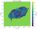
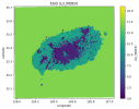
I was curious, so I took a look at the geo.em.do3 file and found issues with your data not plotting in the correct location. There were minor issues in your index file. The corrected index file is below. Also make sure your EGIS_LANDUSE.JEJU.bil is renamed to 00001-01000.00001-01110.
I corrected the known_y, tile_x, and tile_y.
  • Based on your known_lat and known_lon it corresponded to known_y =1110
  • tile_x and tile_y were backwards
I added picture of the default data and your EGIS data for your third domain below.

Code:
type=categorical
category_min=1
category_max=21
projection=regular_ll
dx=0.00083333
dy=0.00083333
known_x=1.0
known_y=1110
known_lat=34.0245836581763
known_lon=126.142083298846
wordsize=1
row_order=top_bottom
tile_x=1000
tile_y=1110
tile_z=1
missing_value=0
units="category"
description="EGIS Landuse"
mminlu="MODIFIED_IGBP_MODIS_NOAH"
iswater=17
islake=21
isice=15
isurban=13

Default.pngEGIS.png
 
Last edited:
Top