Scheduled Downtime
On Friday 21 April 2023 @ 5pm MT, this website will be down for maintenance and expected to return online the morning of 24 April 2023 at the latest

Issues with urban building variables

Rtsquared

New member
I have two problems that I can't seem to figure out (using BEP and BEP+BEM). First, I want to add building data into the wrfinput file overwriting the data taken from the land use index (I am using NLCD). However, I can't get all the variables I need to overwrite to output in that file or the wrfout file even after changing them from "ir" to "ir0h" in the registry (though "i" alone should be sufficient, but it's not- see lines 812-816 in Registry.EM_COMMON). BUILD_HEIGHT and BUILD_SURF_RATIO output, but MH_URB2D, STDH_URB2D, and LF_URB2D are not. I've tried manually adding STDH_URB2D to the wrfinput file but it still doesn't appear in the wrfout file and I can't tell if it's actually being used.

Second, I'm not sure what the difference between BUILD_HEIGHT ("Average building height weighted by plan area") and MH_URB2D ("Mean building height") are. Obviously it has something to do with the building's plan area, but I have been unable to find how BUILD_HEIGHT is weighted. If someone knows, please tell me so I can adjust the variable correctly, at the moment I'm simply overwriting the data with the mean building height.
 
The documentation certainly helps and explains why I can't seem to get the other variables to output- they are single column model only. The documentation is fairly old (2013) and a good deal of the actions it says need to be taken are now included in WRF by default. I'm still unsure about how I need to weight my building height by plan area to properly replace the BUILD_HEIGHT variable (I am working at 444m while NUDAPT is 1km, I used PLUTO to create a 444m NYC dataset to overwrite the defaults which adds detail like Central Park). Anyone know how the building height is weighted? I'm having trouble finding anything about it online.
 
I have two problems that I can't seem to figure out (using BEP and BEP+BEM). First, I want to add building data into the wrfinput file overwriting the data taken from the land use index (I am using NLCD). However, I can't get all the variables I need to overwrite to output in that file or the wrfout file even after changing them from "ir" to "ir0h" in the registry (though "i" alone should be sufficient, but it's not- see lines 812-816 in Registry.EM_COMMON). BUILD_HEIGHT and BUILD_SURF_RATIO output, but MH_URB2D, STDH_URB2D, and LF_URB2D are not. I've tried manually adding STDH_URB2D to the wrfinput file but it still doesn't appear in the wrfout file and I can't tell if it's actually being used.

Second, I'm not sure what the difference between BUILD_HEIGHT ("Average building height weighted by plan area") and MH_URB2D ("Mean building height") are. Obviously it has something to do with the building's plan area, but I have been unable to find how BUILD_HEIGHT is weighted. If someone knows, please tell me so I can adjust the variable correctly, at the moment I'm simply overwriting the data with the mean building height.
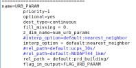
I was able to get variables like MH_URB2D, STDH_URB2D in my wrfinput (after real.exe) and I overwrite them with my own values. But somehow after wrf.exe my own values of MH_URB2D, STDH_URB2D were not taken into effects. This feels similar to your 1st problem and I'm wondering whether you had any solution.
 
Top