Hello,
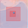
I am trying to get WPS and WRF set up to simulate a storm in the middle of the ocean, as in attached.
When I get to running real.exe, it throws the fatal error:
/Not enough soil temperature data for Noah LSM scheme/
I can see in the logs I generate while running WPS that the ERA5 input data files do have SOILHGT and related soil parameters, and my WPS/WRF tools run perfectly fine over CONUS. It's only this offshore domain that is causing problems (NOTE: I originally thought it was a dateline issue, so I moved the domain to keep it in the western hemisphere).
I think that the problem is specifically with d03, as it does not intersect any land. Does someone have advice on what I might try to get WPS to provide the soil data needed for WRF to run, or another workaround?
Thank you.