Hi
I'm running WRF for one Cyclone case. It is three nested domains. I have lots of questions about how the settings would be more appropriate
From what I have been reading, the met_em files are used for all the running period for D01 and for the other domains uses only met_em files for the first hour (Im using ERA5, hourly values).
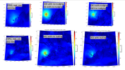
1. If I compare the met_em files (only location of the cyclone) and the results from wrfout_d01 and wrfout_d03 they are not in the same place. But why would be D01 that different from the met_em files? Are met_em files only for boundaries? Can I also make them for hourly initialization?
2. If I nudge values from ERA5, the cyclone in D01 is closer to where it "should" be, although the winds are significantly lower than for the not nudge case. But, why D03 is not affected by the change in the location from the cyclone in D01?
I attach the namelist for the nudge case, in reality I want winds that are similar to the not nudge case but following "better" the track as the ERA5 files does
I am not sure if the initialization is being actually set every hour for all domains. Also it is confusing as to why in the nudge case, D02 and D03 doesn't seem to be affected by the changes in D01.
I was reading that ndown could be a solution, but this is recommended when you have a "long" run in a coarse resolution for D01 and then to "downscale" which is not what I am doing here. If this is the best option, I'm not sure how to do this for 3 domains and having the sst_update, which I also need
Are there any ideas as to what I'm missing in this run?

