You are using an out of date browser. It may not display this or other websites correctly.
You should upgrade or use an alternative browser.
You should upgrade or use an alternative browser.
please assist with lat lon selection
- Thread starter kcmonaka
- Start date
D
Deleted member 3607
Guest
have you tried using the WRFDomainWizard?The approximate center coordinates of the SADC region are:
Latitude: -20.0 degrees Longitude: 25.0 degrees
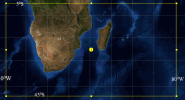
Please use the attached picture as reference. I want to cover a domain like that. View attachment 9805
WRF Portal
WRF Portal is the graphical user interface (GUI) front end for configuring and running both WRF cores: ARW and NMM, as well as configuring and running your own programs/scripts (like post). It simplifies the selection/localization of your domain, the running and monitoring of WRF, running...
esrl.noaa.gov
Ok t
Regards
Thank you. Let me check it out.have you tried using the WRFDomainWizard?
It's a little old but it will do the job while you wait for @Ming ChenWRF Portal
WRF Portal is the graphical user interface (GUI) front end for configuring and running both WRF cores: ARW and NMM, as well as configuring and running your own programs/scripts (like post). It simplifies the selection/localization of your domain, the running and monitoring of WRF, running...esrl.noaa.gov
Regards
D
Deleted member 3607
Guest
I can help with this...message me directlyI tried the suggested grid intervals and still no change
@Ming Chen @kcmonaka
D
Deleted member 3607
Guest
what grid size are you looking for in that domain box?The approximate center coordinates of the SADC region are:
Latitude: -20.0 degrees Longitude: 25.0 degrees
Please use the attached picture as reference. I want to cover a domain like that. View attachment 9805
around 100km.what grid size are you looking for in that domain box?
D
Deleted member 3607
Guest
what is your input data?around 100km.


