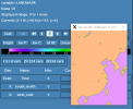
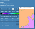
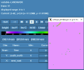
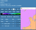
I used the modis_lake dataset in the Landusetype. I have obtained the accurate LANDMASK in the geo_em.d01.nc file and the met_em.d01.*.nc files. However, the execution of real.exe has resulted in the modification of the LANDMASK variable in wrfinput_d01. The value of LANDMASK is more like "lakemask", which means lake = 1, non-lake=0. We also got the XLAND data in the wrfinput_d01 file, which appears accurate and matches the LANDMASK variable in the geo_em.d01.nc and met_em.d01.*.nc files. Is this ok or are there any errors in the LANDMASK variable in the wrfinput file? I used WRFv3.6 and WPSv4.0.
The following images are LANDMASK in geo_em.d01.nc, met_em.d01.*.nc, wrfinput_d01 and XLAND in wrfinput_d01.


The following images are LANDMASK in geo_em.d01.nc, met_em.d01.*.nc, wrfinput_d01 and XLAND in wrfinput_d01.


